Level C Colour Coded Event (Bucklebury Common) 8-Nov-15 - Final Details

Berkshire Orienteers

SCOA League Event - Bucklebury Common

Sunday, 8th November 2015

Final Details

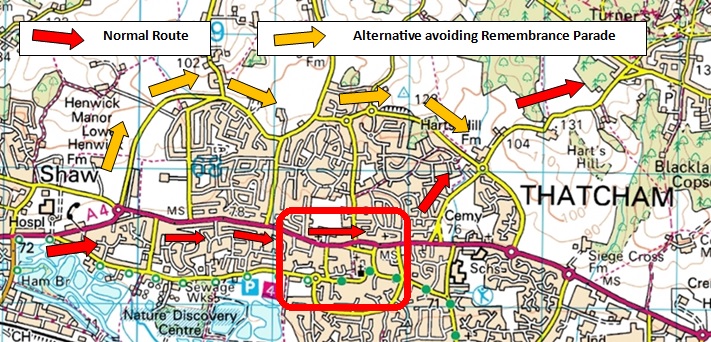
Warning: Remembrance Sunday Road closures in Thatcham 10.30 to 11.30

Location:

The car park and assembly area are on The Green  at Chapel Row , RG7 6PD. Grid ref: SU571696.

Assembly will be on the village field with parking on grass. Please advise the Organiser if you intend to bring a coach.

Travel:

From the EAST turn off the M4 at junction 12, take the A4 West for 2km. At the second roundabout turn right onto the A 340 to Pangbourne.  After 0.5km turn left onto minor road signposted Bradfield. After 2km turn left signposted “Bradfield Southend” and Bucklebury . Proceed for 4km until you reach Chapel Row. Assembly and parking is signposted to the left.

From the WEST and from the A34 BEFORE 10.30 : Leave Newbury going East along the A4 through Thatcham. As you are leaving Thatcham, take a left turn signposted for Upper Bucklebury. Cross roundabout and continue on minor road (via Harts Hill Lane, Broad Lane and the Common)  to Chapel Row where Assembly and the parking is signposted to the right.

Thatcham Diversion AFTER 10.30 At the A4 roundabout on the Western outskirts of Thatcham take the Second turn Tull Way northward. Straight along Bowling Green road , bear left into Heath Lane. Take next turn right (roundbout) . Left turn at roundabout into Floral Way . at second roundabout turn left into Harts Hill lane.

Via Harts Hill Lane, Broad Lane and the Common  to Chapel Row where Assembly and the parking is signposted to the right.   

Please do not use the other minor roads – often narrow - running through the area.

There is parking charge of £1 per vehicle.

Facilities:

The following facilities are available in the Assembly field:.

First Aid by HART FIRST RESPONSE, (Registered Charity 1092333). We aim to help save lives by providing ambulance and first aid cover at local events, and by teaching first aid skills within the community. www.hartfirstresponse.org.uk

Ultrasport

Squash

Toilets

Registration:

Opens at 9.30.

White and Yellow  course runners  must  collect their maps from Registration. All other Competitors who have pre-entered and have their own Emit e-card should go straight to the Start.

Start times are between 10:00 and 12:00.

Individual start times will be published on Fabian 4 and displayed at the Start and Registration.

Note that for simplicity and based on expected numbers we are issuing start times by Start Blocks of 30 minutes   so that you can join the Start queue at any time within the 30 minutes after your start time . As a result everyone, who is  in the same start block,  will have the same start time  ie 10.00. 10:30, 11:00, 11:30   and for helpers on late runs 12:00.  

EOD

Courses may be entered on the day subject to map availability. Starts are between 10.00am – 12.00pm. EOD entry is £12.00 for adults if BOF members otherwise £14 and £5.00 for all children .

For pairs and Groups one entry fee is charged  - Additional maps  £1

Courses close at 2.30pm

All Entries on the day will given a form with your entry details – hand this in at the start.

String Course

A Free string course is provided  on Chapel Row Common  200 metres to the North west of the car park field  start times from 10.00 to 12.00. Follow the signs to the String course registration – take care crossing the roads on the way to the course. For this reason children under 16 must be accompanied to the String course by an adult.

Emit Card

Issue and

Return:

Competitors hiring Emit cards should collect them from Enquiries before going to the start. Hired Emit cards will be collected at download. A charge of £45 will be made for lost cards.

Start

The route to the Start is signposted from the far South–East corner of the parking  field.  There is a   walk of  1 km  to the start and back from the finish – allow  15 minutes. The route is initially along a track and then on a quiet residential road  before turning right along the verge for 30 metres and then take care crossing the minor road (Hatch Lane) and going through the gate. Immediately turn right BEFORE the  house. After 100m the path forks left for the Start  (the Finish is straight on).

At this point there is an area to leave clothing  but this will be unmanned and so will be used at your own risk


DO NOT WALK directly down Hatch Lane – there are no verges and traffic is often fast.


The Start is a punching start

Loose description sheets will be available in the start lanes except for the White and Yellow courses.  White and yellow courses must collect their maps from REGISTRATION prior to starting.

Road Crossings

For the Green, Blue and Brown Courses  only there are two manned road crossing points for your safety on the fast and busy East-West road from Chapel Row to Upper Bucklebury.

Please follow the advice from the Marshalls.

There are controls one each side of the road – you must punch both.

One minute allowance is given for each road crossing


In addition  all courses  Light Green and longer cross the  much quieter North-South Roads which are not marshalled .

TAKE CARE in crossing ANY road

White , Yellow and Orange courses do not cross any roads 

Course

Length

Climb

No. controls

Descriptions

White

2.0km

15m

10

Text

Yellow

2.1km

15m

7

Text

Orange

2.9km

20m

11

Text

Light Green

3.9km

30m

10

Pictorial

Short Green

4.1km

30m

10

Pictorial

Green

5.1km

40m

16

Pictorial

Blue

7.8km

120m

25

Pictorial

Brown

9.5km

170m

24

Pictorial

Course Close

Courses closes at 2.30

Finish

There is one finish for all courses . – Squash is available in the Assembly field

Follow  the “Start” route back to the Car park field and the Download tent.

ALL competitors must report to the DOWNLOAD tent  even if they retire.


WARNING: at around 12.45  the local hunt will be walking their horses and hounds along the  minor road (Hatch lane)  which runs alongside the field and crossed the route from the Finish

SCOA League Prizes


Prize Giving for the  2014-2015 season will take place at 12.30 in the Assembly field

Map

Scale 1:10,000, 5m contours, updated 2015 by Katy Stubbs. Courses and control descriptions will be over printed on waterproof paper

Note that seasonal bracken is not mapped.

Terrain

Areas of heathland and mainly deciduous woodland interspersed with dwellings - all with a complex path and track network. Some detailed contours and features on the north side of the map. It is 10 years since most of the area has been used for an event.

There are some extraction lanes, seasonal and animal tracks which are not on the map.

Bracken will be  encountered  on the Brown, Blue, Green, Short Green and Light Green courses.  Most can be avoided as there are numerous small paths dotted about the area.

There is bracken in both areas south of the East-West road but White to Orange courses should not be affected

Bio Security

Please come to the event with clean and dry shoes and clothing. After your run please follow the guidance that helps protect our precious environment:

·         Check

·         Clean

·         Dry

Before leaving the event check your clothing and equipment and remove any mud, soil or leaf litter.

Once home thoroughly clean your footwear and clothing and then leave it to dry for as long as possible. Many invasive non-native species are able to survive in damp corners for very long periods of time, but are less able to survive if the equipment is thoroughly dried.

Photography

The club has designated photographer(s) and details are available from registration. Photographs from the event may be used by the club and made available on the internet in accordance with British Orienteering guidelines. Please speak to a club official at registration if you have any concerns

General

Safety:

- Please take care when crossing and walking along Forest roads.

- There is public access to Bucklebury Common , please respect the rights of others, particularly the horse riders.

- Please report to download even if retiring as this will ensure we can check you have returned safely. Competitors travelling alone are encouraged to leave a set of keys at registration.

- Competitors are advised to carry whistles.

- Competitors take part at their own risk and are responsible for their own safety.

Accidents:

- First Aid by Hart First Response in Assembly field


-Accident and Emergency unit :

A&E
Royal Berkshire
NHS Foundation Trust
Centre Block
Craven Road
Reading
RG1 5AN

0118 322 7020

Officials

Planner: Andrew Graham

Organiser: Peter Entwistle  07814 938057

Email: events@bko.org.uk

Controller: Andy McGregor  (BADO)

IMPORTANT OFFICIAL NOTICES:

  • Competitors take part at their own risk
  • The personal data you give will be used by the event organisers only for the purpose of processing/publishing entries and results and as required by our insurers. Entry details will be stored in a computer. Submissions of an entry for the event will indicate your acceptance of this procedure.
  • In the event of cancellation of the event, part, or all of your entry fee may be retained.
  • The club has designated photographer(s) and details are available from registration. Photographs from the event may be used by the club and made available on the internet. Please speak to a club official at registration if you have any concerns.

Level C Colour Coded Event (Yateley Heath) 29-Sep-13 - Final Details

THIS IS A TEST ENTRY AND SHOULD BE DELETED !!!!

Final Details

Final Details

Andy Parry

Saturday 30th May 2015

Great Hollands, Bracknell

BML UK Urban League and S.E.O.U.L.

Event Details

29 May - Version 3 (Items in red have been updated - please check in case of later updates)

Berkshire Orienteers welcome you to the event!

Parking/Travel:

Parking will be in a section of the Fujitsu car park in Lovelace Road, Bracknell. Postcode – RG12 8YS, GR SU853683. It will be signed from the A329 at the junction with Doncastle Road (this is the junction the M4 side of the Twin Bridges Roundabout). A charge of £1 per car will be donated to ‘Action for Children’ who is Fujitsu’s Charity Partner.

The event is also within walking distance of Bracknell Railway Station using a mainly off road route. Turn left out of the station and cross over the railway line, continue to Old Bracknell Lane (West), Turn right and continue to the roundabout through the underpass. Head straight on, to the Southern Industrial Area, heading south parallel to Mill Lane. Turn right into Ellesfield Avenue, at the second roundabout turn left into Lovelace Road. Follow the signs to the assembly area.

The Assembly area is two minutes walk from the parking area on a football pitch on Ringmead

Facilities

  • Toilets, First Aid, Tom’s burger wagon and Ultrasport at Assembly.
  • There will be no string-course at this event but there is a lovely circular walk through the ancient woodland adjoining the assembly. The area is called Northerams Wood.(http://www.bracknelltowncouncil.gov.uk/northerams.php)
  • First Aid: Hart First Response Medical Services will be available at Assembly. The nearest hospital is Frimley Park Hospital, Portsmouth Road, Camberley, GU16 7UJ.

Dogs:

Please keep your dogs on leads at assembly. Not permitted on courses. Ensure you clear up after your dog.

EOD and e-tag collection will be open in Assembly, between 10.00 to 12.00. There will be limited EOD dependent on map numbers. EOD fees will be:

  • BOF Seniors: £14
  • Non BOF Seniors: £16
  • Juniors: £7

Competitors without their own EMIT cards will be charged £1.50 EmiTag hire.

Start and Finish:

  • Starts are between 10.30 and 12.30. There is one start for all courses which is approximately 20 minutes walk from Assembly. The route to the start does cross a number of minor roads so we ask parents to escort juniors to the start.
  • For this event we are not setting start times, once you have parked (or arrived at assembly), collect your emiTag from Registration and go to the start.
  • Finish adjoins the Assembly area so there will be no clothing dump. If you plan to cycle or walk to Assembly you may leave bags around the registration tent at your own risk. There is an area where club tents/banners may be erected next to the finish area.

EMIT Touch-Free Controls and EmiTags:

  • For this event we are using the IOF approved Emit Touch-Free system (2014 version), which consists of electronic controls and a wrist/hand-carried control card, called an emiTag (see right). The emiTag is mounted on a 20cm Velcro strap to be carried either around the wrist or the hand. Visible from the front when a ‘punch’ has been recorded is a bright LED, which will flash for 10 seconds, rapidly at first, when a punch has been recorded. If the competitor remains in range of the control the emiTag will continue to flash. There is no need to ensure it flashes for 10 seconds – one quick look is all that is required.
  • The emiTag will be cleared and the internal clock started by crossing the start line. The LED will flash to indicate that this has occurred correctly.
  • Should the flashing LED not be seen the competitors must use the standard pin punch attached to each control and record the punch on the map.
  • The system to be used at this event consists of 23 x 17 x 3cm Touch-Free Pro (TFP) control units (pictured right). This has a maximum communication range of about 70cm, dependent on the orientation of the emiTag. It is recommended that the emiTag passes within 30cm of the control face; the emiTag must be within range of the TFP for at least 0.07 seconds in order to record a ‘punch’. Several people can punch at the same time as long as they are all within range and each e-tag will record correctly. If you run close past another control it will also record this punch but as each e-tag can hold 500 reads, so this is not a problem.
  • The TFP control units will primarily be hung vertically on street furniture for this event and will be in conjunction with a standard orienteering kite and a back-up pin punch (as there are no back-up cards for the touch free system).

Courses:

The courses are summarised in the following table:

Course Age Distance Height Controls
A Mens Open 8.4km 110m 28
B Mens Vet,Women Open 7.2km 95m 25
C Men Super Vet, Womens Vets 5.7km 60m 18
D Men Ultra Vet, Women Super Vet 4.1km 55m 15
E Women Ultra Vet 3.5km 40m 14
F Men Junior, Women Junior 3.0km 15m 16
G Men / Women Young Junior 2.2km 10m 12

The current distance is the straight line between controls, and actual distances will be further than those published. However the nature of the area means that there are no large detours between controls and course distances are to the top end of course guidelines for this reason.

Nettles have come up a lot in the last week. Although I don't want to stop anyone wearing shorts, some of the woodland, particularly with undergrowth, will have significant bracken and nettles. In most cases going round is only a small detour

Mapping:

  • For courses A-E, two maps are being used for the event, printed back to back, both at 1:4,000, A3. On the second map, the final control on Part 1 is the start triangle on Part 2. At this point in the control descriptions, it states: "Please turn over the map".
  • Great Hollands has been completely resurveyed for the event by Katy Stubbs. The Birch Hill map has been updated as necessary from the 2012 map with the addition of a new area joining the two maps.
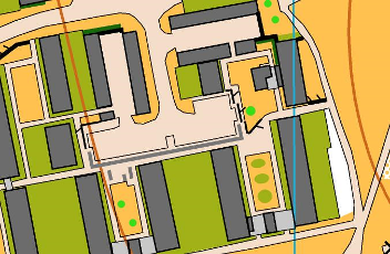
  • In Great Hollands nearly all the parking areas within the estate have low walls or low fences partially surrounding them which can be crossed easily by an adult. Every effort has been made to map these and the breaks in them, which vary from parking area to parking area. In some cases they have multiple small gaps, which would make the low wall symbol very difficult to read especially at running speed, therefore the gaps have been omitted. Runners should have minimal difficulty finding a gap to cross these longer walls.
  • Individual trees have usually been mapped except where there is a significant area where the scattered trees symbol has been used.
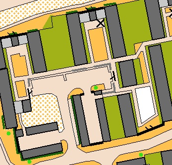
  • X’ has been used for a bench,
  • O’ is a statue or monument,
  • X' is a large tree stump/partially fallen tree.
  • Where high or low fences and walls surround the settlement (olive green) symbol these have not been mapped. Due to the intricate nature of the estate these would only clutter the map and cause problems with readability. No competitor is permitted to cross into the settlement areas regardless of whether they are surrounded by walls or fences or not.

Safety:

  • Be warned that mown grass areas where cars have often been parked off road within the estates are frequently rutted with ankle twisting ruts and small holes (as the mapper has found to her cost!).
  • Car keys may be left at Registration.
  • Please remember, Great Hollands is residential estate and that there will be pedestrians, cyclists and dog walkers around the courses. Please be courteous to other users of this area.
  • ALL COMPETITORS MUST DOWNLOAD EVEN IF YOU DO NOT FINISH THE COURSE.

Results:

Results will be posted on http://www.bko.org.uk

Course Closure:

Closure time for all courses is 2.00pm.

We would like to thank Fujitsu for permitting us to use their car park and Bracknell Town Council for their support and for permitting us to use the football pitch for our assembly.

Officials:

  • Planner: Mark Foxwell (BKO)
  • Organiser: Fiona Clough (BKO) – Contact: events@bko.org.uk
  • Controller: Bernie Fowler (BAOC)

IMPORTANT OFFICIAL NOTICES:

  • Competitors take part at their own risk
  • The personal data you give will be used by the event organisers only for the purpose of processing/publishing entries and results and as required by our insurers. Entry details will be stored in a computer. Submissions of an entry for the event will indicate your acceptance of this procedure.
  • In the event of cancellation of the event, part, or all of your entry fee may be retained.
  • The club has designated photographer(s) and details are available from registration. Photographs from the event may be used by the club and made available on the internet. Please speak to a club official at registration if you have any concerns.

Level C Urban Event (Great Hollands) 30-May-15 - Final Details

Saturday 30th May 2015

Great Hollands, Bracknell

BML UK Urban League and S.E.O.U.L.

Event Details 

29 May - Version 3 (Items in red have been updated -please check in case of later updates)

Berkshire Orienteers welcome you to the event!

Parking/Travel:

Parking will be in a section of the Fujitsu car park in Lovelace Road, Bracknell.  Postcode – RG12 8YS, GR SU853683.  It will be signed from the A329 at the junction with Doncastle Road (this is the junction the M4 side of the Twin Bridges Roundabout).  A charge of £1 per car will be donated to ‘Action for Children’ who is Fujitsu’s Charity Partner.

The event is also within walking distance of Bracknell Railway Station using a mainly off road route. Turn left out of the station and cross over the railway line, continue to Old Bracknell Lane (West), Turn right and continue to the roundabout through the underpass. Head straight on, to the Southern Industrial Area, heading south parallel to Mill Lane. Turn right into Ellesfield Avenue, at the second roundabout turn left into Lovelace Road. Follow the signs to the assembly area.

Assembly:

The Assembly area is two minutes walk from the parking area on a football pitch on Ringmead. 

Facilities:

  • Toilets, First Aid, Tom’s burger wagon and Ultrasport at Assembly.
  • There will be no string-course at this event but there is a lovely circular walk through the ancient woodland adjoining the assembly.  The area is called Northerams Wood.(http://www.bracknelltowncouncil.gov.uk/northerams.php?)
  • First Aid: Hart First Response Medical Services will be available at Assembly.  The nearest hospital is Frimley Park Hospital, Portsmouth Road, Camberley, GU16 7UJ.

Dogs: Please keep your dogs on leads at assembly.  Not permitted on courses. Ensure you clear up after your dog.

Registration: EOD and e-tag collection will be open in Assembly, between 10.00 to 12.00.  There will be limited EOD dependent on map numbers.  EOD fees will be:

· BOF Seniors: £14

· Non BOF Seniors: £16

· Juniors: £7

Competitors without their own EMIT cards will be charged £1.50 EmiTag hire.

Start and Finish:

  • Starts are between 10.30 and 12.30.  There is one start for all courses which is approximately 20 minutes walk from Assembly. The route to the start does cross a number of minor roads so we ask parents to escort juniors to the start.
  • For this event we are not setting start times, once you have parked (or arrived at assembly), collect your emiTag from Registration and go to the start.
  • Finish adjoins the Assembly area so there will be no clothing dump. If you plan to cycle or walk to Assembly you may leave bags around the registration tent at your own risk.  There is an area where club tents/banners may be erected next to the finish area.

EMIT Touch-Free Controls and EmiTags:

  • For this event we are using the IOF approved Emit Touch-Free system (2014 version), which consists of electronic controls and a wrist/hand-carried control card, called an emiTag (see right).  The emiTag is mounted on a 20cm Velcro strap to be carried either around the wrist or the hand.  Visible from the front when a ‘punch’ has been recorded is a bright LED, which will flash for 10 seconds, rapidly at first, when a punch has been recorded. If the competitor remains in range of the control the emiTag will continue to flash.  There is no need to ensure it flashes for 10 seconds – one quick look is all that is required.
  • The emiTag will be cleared and the internal clock started by crossing the start line. The LED will flash to indicate that this has occurred correctly.
  • Should the flashing LED not be seen the competitors must use the standard pin punch attached to each control and record the punch on the map.

  • The system to be used at this event consists of 23 x 17 x 3cm Touch-Free Pro (TFP) control units (pictured right).  This has a maximum communication range of about 70cm, dependent on the orientation of the emiTag.  It is recommended that the emiTag passes within 30cm of the control face; the emiTag must be within range of the TFP for at least 0.07 seconds in order to record a ‘punch’.  Several people can punch at the same time as long as they are all within range and each e-tag will record correctly.  If you run close past another control it will also record this punch but as each e-tag can hold 500 reads, so this is not a problem.
  • The TFP control units will primarily be hung vertically on street furniture for this event and will be in conjunction with a standard orienteering kite and a back-up pin punch (as there are no back-up cards for the touch free system).

Courses:

The courses are summarised in the following table:

Course Age Group Distance Height Controls

A Mens 0pen 8.4km 110m 28

B Mens Vet,Women 0pen 7.2km 95m 25

C Men Super Vet, Womens Vets 5.7km 60m 18

D Men Ultra Vet, Women Super Vet 4.1km 55m 15

E Women Ultra Vet 3.5km 40m 14

F Men Junior, Women Junior 3.0km 15m 16

G Men / Women Young Junior 2.2km 10m 12

The current distance is the straight line between controls, and actual distances will be further than those published. However the nature of the area means that there are no large detours between controls and course distances are towards to the top end of course guidelines for this reason.

Planner’s Comment: Nettles have come up a lot in the last week. Although I don't want to stop anyone wearing shorts, some of the woodland, particularly with undergrowth, will have significant bracken and nettles.  In most cases going round is only a small detour 

Mapping:

  • For courses A-E (and possibly F - to be confirmed), two maps are being used for the event, printed back to back, both at 1:4,000, A3.  On the second map, the final control on Part 1 is the start triangle on Part 2.  At this point in the control descriptions, it states: "Please turn over the map".
  • Great Hollands has been completely resurveyed for the event by Katy Stubbs. The Birch Hill map has been updated as necessary from the 2012 map with the addition of a new area joining the two maps.
  • In Great Hollands nearly all the parking areas within the estate have low walls or low fences partially surrounding them which can be crossed easily by an adult.  Every effort has been made to map these and the breaks in them, which vary from parking area to parking area.  In some cases they have multiple small gaps, which would make the low wall symbol very difficult to read especially at running speed, therefore the gaps have been omitted.  Runners should have minimal difficulty finding a gap to cross these longer walls. 
  • Individual trees have usually been mapped except where there is a significant area where the scattered trees symbol has been used.
  • Special symbols:

X’ has been used for a bench,

Ois a statue or monument,

Xis a large tree stump/partially fallen tree.

  • Where high or low fences and walls surround the settlement (olive green) symbol these have not been mapped.  Due to the intricate nature of the estate these would only clutter the map and cause problems with readability.  No competitor is permitted to cross into the settlement areas regardless of whether they are surrounded by walls or fences or not. 

For the previous maps of the areas being used, see:

Safety:

  • Be warned that mown grass areas where cars have often been parked off road within the estates are frequently rutted with ankle twisting ruts and small holes (as the mapper has found to her cost!).
  • Car keys may be left at Registration.
  • Please remember, Great Hollands is residential estate and that there will be pedestrians, cyclists and dog walkers around the courses.  Please be courteous to other users of this area.
  • ALL COMPETITORS MUST DOWNLOAD EVEN IF YOU DO NOT FINISH THE COURSE.

Results: Results will be posted on http://www.bko.org.uk

Course Closure: Closure time for all courses is 2.00pm.

Acknowledgements:  We would like to thank Fujitsu for permitting us to use their car park and Bracknell Town Council for their support and for permitting us to use the football pitch for our assembly.

Officials

  • Planner: Mark Foxwell (BKO)
  • Organiser: Fiona Clough (BKO) – Contact: events@bko.org.uk
  • Controller: Bernie Fowler (BAOC)

IMPORTANT OFFICIAL NOTICES:

  • Competitors take part at their own risk
  • The personal data you give will be used by the event organisers only for the purpose of processing/publishing entries and results and as required by our insurers.  Entry details will be stored in a computer.  Submissions of an entry for the event will indicate your acceptance of this procedure.
  • In the event of cancellation of the event, part, or all of your entry fee may be retained.
  • The club has designated photographer(s) and details are available from registration.  Photographs from the event may be used by the club and made available on the internet.  Please speak to a club official at registration if you have any concerns.

Concorde Chase (Cold Ash) 25-Jan-15 - Final Details

Travel directions and parking

Follow the brown signs to Newbury Showground from the roundabout at the M4-A34 junction (M4 Junction 13, OS grid reference SU480728). On exiting the roundabout north towards the A34, keep left.  Before joining the A34 fork left at the slip road, signed to Chieveley, Hermitage and Beedon. At the top of the slip road, turn right, signed to Hermitage. The event will be O signed from there. Parking is in a field just off the minor road from Hermitage to Yattendon. Nearest postcode RG18 9XP, OS grid reference SU520738. If coming from the South, be careful not to stay on the A34 as you will by-pass the junction!

Parking Fee £1 per Car, please try to have this ready as you arrive.

Enquiries/Entry on the day/Emit hire

Enquiries, entry on the day & hired Emit card collection will open from 9.30am to 12 noon.  Entry on the day is available for all age class courses, subject to map availability.  Cost - £14 for BOF seniors (£16 for non BOF members); £5 for juniors. Emit hire is £1.50 for seniors and free for juniors and students. Lost Emit cards will be charged at £45. The string course is free.

Lone travellers are encouraged to leave car keys with Enquiries.

Start.

Competitors who have pre-entered should go straight to the start. Starts are from 10am to 12.30pm.  Call up will be at -4 minutes. Start Times for competitors will be pre-allocated but it is a punching start. If you are late, you will be slotted in to the next available time.

The route to the start is via the south west corner of the assembly field and is roughly 100 metres on exit.  The route will be marked.  Please note that it passes close to the string course at one point and take due care.

Due to recent extensive logging there are several deeply rutted extraction lanes that competitors will have to navigate.

Finish

The finish is equally close to the assembly field and returns via the south east corner of the field.  Courses close at 2.30pm. Please make sure that you are back by then. Please report to the download tent even if you retire.

String course

The String course is accessed via the south east corner and is adjacent to the assembly field.   

Facilities.

Ultrasport and Tom’s Burger will be in attendance.

Toilets will be in the Assembly field.

There will be a first aid unit in the field near the entrance.

Water will be provided on entry to the assembly field.  Bin-liners will be provided for drinks but please take your own rubbish away with you.  

Courses

Classes

Course

Length (km)

Climb (m)

Number of Controls

M21

Black

11.8

355

33

M35,M40

Brown

10.5

315

31

M18,M20,M45,M50,

W21,M21S

Short Brown

9.2

265

21

M16, M55, M60, W35, W40, M35S, M40S,

Blue

7.6

230

18

M65, W18, W20, W45, W50, M20S, M45S, M50S, W21S

Short Blue

5.4

170

17

M70, W16, W55, W60, M55S, M60S, W35S, W40S

Green

4.7

140

16

M75, M80, M85, M90, W65, W70, M65S, W18S, W20S, W45S, W50S

Short Green

3.8

130

14

W75, W80, W85, W90, M70S, M75S, M80S, M85S, W55S, W60S, W65S, W70S

Very Short Green

3.1

115

10

M14, W14, M16B, W16B

Light Green

3.5

120

14

M12, W12, M14B, W14B

Orange

2.8

110

9

M10, W10, M12B, W12B

Yellow

2.1

50

10

M10B, W10B

White

1.6

35

10

Those on white and yellow courses will need to collect their maps at the start. A copy will also be held at enquiries for you to get a preview if you wish

Maps

The map scale is 1:10, 000 with 5 m contours and minor updates have been made to reflect current forest conditions (up to the end of December 2014).

The longer courses (Green to Black) are printed at A3, whilst the shorter courses (White to Short Green) are printed at A4.

The following special symbols are being used and will be shown on the competition maps:

Feature

Map Symbol

Pictorial

Rootstock

Brown

X

IOF U

Distinctive tree

Green

O

IOF

Small shooting tower

Black T

T

not used

Manmade feature - Water tank

Blue circle

O

not used

Manmade feature – scrap metal

Black circle

O

O

Maps do not have a full legend, only non-ISOM and special symbols are shown.

Control Description Sheets

Light Green to Black courses will have pictorial descriptions printed on the map. 

White, Yellow and Orange courses will have text descriptions printed on the map. 

Loose control descriptions on waterproof paper will be available at the Start.

Terrain

Mixed, mainly deciduous, woodland with generally good runnability except where forest thinning has taken place in the last couple of years which has resulted in localised patches of brashings.  The area has several gently sloping hills and a fairly extensive path network.

Forestry thinning operations in the northern parts of the map have continued into January, past the date that the maps went to print.  Thinning has improved visibility but worsened runnability; the green-striped ‘slow run undergrowth’ screen shows the affected areas. As well as the brashings you may encounter small piles of logs. Numerous recent extraction lanes in the thinning areas have not been mapped.  Wherever possible, courses have been designed to avoid the worst of the brashings.  The forestry operations have also churned up some of the main tracks and rides.

If it has been wet in the weeks before the event, depressions may be full of water and rides very muddy. In general, the forest and small paths offer better running than larger paths and rides. Wellies would be a good idea for those walking round the white and yellow courses.

Additional safety warning/information

The longer courses (Green to Black) cross minor roads. Visibility varies according to where you cross.  There will be no manned crossings.  Please be alert to local traffic which can be fast at times.

Horse riders, cyclists and dog walkers may be on public paths in the forest. They will have been alerted to the event. Please be respectful at all times so as to enable continued access to this area.

Shadowing

No shadowing will be allowed before your own run. The shadower must not pick up a map at the start. 

Dogs

Dogs are permitted but need to be on leads in the assembly and competition areas as the woods contain pheasant rearing areas. Please respect this requirement so as to preserve our access to these woods.

Electronic Punching

EMIT electronic punching system will be used. A demonstration EMIT control will be available in the assembly field.  It is the competitor’s responsibility to check that their EMIT card has been registered, including on the back-up card, at each control and the Finish.  Reinstatement for missing electronic punches will only be made on visible evidence of the correct pin punch on the back-up card.  Hire cards will have a named back-up card on collection.  Spare back-up cards will be available at the registration tent. It is essential that all competitors visit Download whether or not they have finished their course. 

Clothing and Safety Equipment

The torso and legs must be covered.  The Organiser may require a waterproof jacket to be worn or carried if the weather is bad - if so, notices will be displayed in Assembly and on the route to the start.  For safety reasons we recommend you carry a whistle (though it is not obligatory).  The distress signal is six short blasts, wait one minute, then repeat.  

Results

Results will be displayed in the Assembly field. Final results will be posted on the BKO website at www.bko.org.uk.

Complaints, Protests and Appeals

In the first case the competitor should discuss any concerns with the Planner, Controller or Organiser, dependent on the problem.  If this does not resolve the issue then Complaints should be made in writing via Enquiries.  A Complaint should be made as soon as possible after the problem is identified and no more than 15 minutes after the last result being displayed.  The Organiser is the adjudicator.  A Protest can only be made against the Organiser’s decision, in writing to the Controller again via Enquiries.  Protests and appeals will be handled under Rule 9 and Appendix G of the 2013 British Orienteering Rules

Photography

In accordance with British Orienteering Child Welfare Policy and Procedures, we request that any person wishing to engage in any video, zoom or close range photography should make themselves aware of British Orienteering policy.  The Organiser reserves the right to challenge anyone who is giving cause for concern.  If anyone has concerns about inappropriate or intrusive photography they should raise them with the Organiser. 

Safety

Orienteering is an adventure sport. All competitors take part entirely at their own risk and are responsible for their own safety. 

Please note that livestock has been kept in the parking/assembly field - we recommend you wash your hands, if possible, before eating.

There have been ticks reported in the area.  Check for them after your run.

First Aid is being supplied on site by ABC Medical Services. The nearest hospitals with Accident and Emergency departments are as follows: Royal Berkshire Hospital, Craven Road, Reading, RG1 5AN, telephone +44 (0)118 3225111, (Closest); Great Western Hospital, Swindon, SN3 6BB, tel +44 (0)1793 604020, signposted from Junction 15 M4 motorway. Minor Injuries Unit, West Berkshire Community Hospital, London Road, Thatcham, RG18 3AS, open 9am to 10pm, tel +44 (0)1635 273300. 

Ash Dieback precautions

The following precautions have been recommended by BOF - arrive with all of your kit, especially footwear, fully cleaned since its last outing.  After your run, place all your kit in a plastic bag to prevent spreading fungal spores.

Full details of Ash Dieback precautions can be found at British Orienteering’s website Click Here.

Cancellation

Cancellation is a last resort. However if very bad weather is forecast or some unforeseen event makes it necessary to cancel, a notice will be placed on the BKO website. If the event is cancelled BKO reserves the right to retain a part of the entry fee to cover unavoidable expenses.

Level C Colour Coded Event (Black Park) 26-Oct-14 - Final Details

BERKSHIRE ORIENTEERS
BKO Level C & SCOA League Event
Sunday 26th October 2014
Black Park, Wexham, Buckinghamshire
PLEASE REMEMBER THE CLOCKS GO BACK ON SATURDAY NIGHT ! 
FINAL DETAILS
General

The event will be signed from the A412 Uxbridge Road approximately 2 miles North of the junction with the A4 in Slough or 3.3 miles South-West of the junction with the A40/M40.


GR TQ005832, nearest Postcode SL3 6DT.


Parking is in the Black Park Country Park car park. This is a Pay and Display Car Park – fees for cars are £3.50 and £7.50 for Minibuses (Blue badge holders and motor bikes – free). Remember to bring some change for the machines.


There will be a small Artisan Food and Craft Market in the northern area of the car park (in the new overflow car park) between 10am and 4pm.


Start and Finish will be about a 400m and 250m walk respectively from the Registration and Download tents, which will be close to the car park.


Black Park is widely used by the local community for walking, dog walking and cycling. Please be courteous and considerate to other users of the park.

Courses Colour Length Controls
Brown 8.8 Km 22
Blue 6.6 Km 17
Green 4.8 Km 19
Short Green 3.1 Km 13
Light Green 3.6 Km 11
Orange 2.6 Km 10
Yellow 2.1 Km 10
White 1.5 Km 8

The Brown course has a double-sided map. On reaching the last control printed on the first side of the map, turn the map over; that control will be depicted on the reverse as a start triangle.


White and Yellow course maps should be collected from Registration. There will be a free String course close to the car park.


All courses close by 2pm. Collection of early controls on the longer courses may begin before this time.

Registration

Registration will be open from 10am to 11.30am for EMIT collection and EOD (subject to map availability).

EOD fees:

  • BOF member seniors £8
  • Non BOF member seniors £10
  • Juniors £4.50

EMIT hire will be £1.50 for seniors, free for juniors/students, lost cards will be charged at £45.


Competitors who have pre-entered with their own EMIT cards may go straight to the Start. Those who have hired EMIT cards will need to collect them from Registration. Competitors travelling alone are encouraged to leave their car keys at Registration.

Facitilies First Aid will be located adjacent to Registration. A small Kiosk cafe is located close to Registration and provides hot drinks and snacks; there are indoor toilets (with running water) to the side of the café available to all users of the park.
Planners Notes

Black Park is a country park consisting mainly of mixed woodland with a good path network. The area is fairly flat, with little climb on any course. There is a substantial area of open heathland in the NE part of the park, this is out of bounds as it is a SSSI. The Blue and Brown courses do go along tracks through it to get to the Northern end of the park, please keep to the tracks. There are other SSSI’s within the woods, also marked as out of bounds, most of which are very wet marshes. Please respect all of these, unfenced ones are not taped but are easily avoided by all courses.


There are some areas where the bracken is high, courses have been planned to avoid the worst of these. Blue and Brown courses also go into a second mixed fenced area containing some cattle.


There are quite a number of hides in the woods, only the more substantial ones have been mapped. The symbol for these is X on both maps and descriptions. Note that these hides can appear and disappear at short notice. Seats and picnic tables are marked with an O.


There are also some large log piles in parts of the area, which are mapped as out of bounds, please do not climb on or attempt to cross them.

Map Waterproof A4 map. Scale 1:10,000, 5m contours, updated September/October 2014.
Control Descriptions Control descriptions are printed on the map. Loose control descriptions (not waterproof) will be available in the start lanes. White, Yellow and Orange courses use text descriptions; all other courses use IOF symbols.
Start

The Start is about 400m walk from Registration. The route will be marked. There are no pre-set start times, just turn up and run. The walk to the start does not pass the finish and there will be no clothing dump.


Start times will be from 10:30am until 12:00pm. If entry numbers on the day are very high on the Blue course, then start times will be extended to a maximum of 12:30pm for that course only.


Call-up will be at -4 minutes for EMIT check. Loose control descriptions will be available at -3 minutes. Blank Maps will be displayed at -2 minutes.


White and Yellow course maps will be provided at Registration in order that competitors may review their courses before they start

Finish The Finish is approximately 250m from Download/Registration. Remember, you must DOWNLOAD even if you retire.
Results Results will be displayed near Download and available via the BKO website by Sunday evening.
Dogs Dogs are welcome, please clear up after them.
COURSES CLOSE AT 2PM – ENSURE YOU REPORT TO DOWNLOAD EVEN IF YOU DO NOT COMPLETE YOUR COURSE.
Officials   Name Email
Planner Ken Ricketts events@bko.org.uk
Controller Katy Stubbs  
Organiser Fiona Clough fixtures@bko.org.uk
Personal Data you give will be used by the event organisers and their agents only for the purpose of processing and publishing the event entries and results, for conducting safety checks and to validate British Orienteering insurance cover. Submission of an entry for the event will indicate your acceptance of this procedure.
Acknowledgements Many thanks to Buckinghamshire County Council for permitting us to use Black Park for this event.
Event Cancellation In the unlikely event of a cancellation a notice will be placed on our website (www.bko.org.uk). BKO reserve the right to retain enough of your fees to cover costs.
YOU TAKE PARK IN THIS EVENT AT YOUR OWN RISK AND ARE RESPONSIBLE FOR YOUR OWN SAFETY
       
                  www.bko.org.uk  

Pages