Level C Urban Event (Great Hollands) 17-Jun-18 - Final Details

Sunday 17th June 2018

Great Hollands, Bracknell

SEOUL League Event

Final Details

 BKO thanks you for attending this event. 

Results at a per-course level are now available on link

The decision on adjustments due to lost/stolen control (190) and not functioning correctly control (159), was taken by me as Organiser. If you have any questions or concerns, please address them to me. 

Other than the issues with a small number of controls, we hope you enjoyed the event, including the lovely setting as well as the challenging courses. 

Hoping to see you all again soon

Eoin on behalf of BKO Events

Updated : 18/June 2018

Venue and Travel:

Event HQ : West side of car-park of South Hill Park, Ringmead, Bracknell RG12 7NF.

By Car : from roundabout at the junction of A3095 and Great Hollands Road, follow Hanworth road, then immediately turn right into Ringmead (note : traffic-calmed, 20mph), event HQ will be on your right after about a half-mile. Both event car-parks are accessed via Ringmead (map attached). 

Parking : Use public car-parking (free), either at Leppington (150 m walk to Assembly) or Bracknell Hockey Club (750 m). NB we have been asked NOT to park at South Hill Park to minimise impact to ongoing activities at the Arts Centre and park. Also Bracknell Council rep strongly advises against parking in residents streets. Please see attached map for recommended parking locations -- note the file is in small type at the top of this Final Details page. 

Public transport : from Bracknell Bus Station (adjacent to train station), take 171, 172 or 4 bus, alight at Birch Hill stop, near to large Sainsbury's. From there it is a level 6-700 m walk to Assembly. Even on a Sunday there are 3 -4 buses per hour and the total journey time should be about 20 minutes. 

Facilities:

Toilets - please use the public WC adjacent South side of car-park, or use the facilities in South Hill Park arts centre. Use the arts centre discreetly, being mindful of other (non-orienteering) users. 

First Aid by HART FIRST RESPONSE (www.hartfirstresponse.org.uk).

If needed, the nearest A&E is 

Frimley Park Hospital
Portsmouth Road
Camberley
Surrey
GU16 7UJ


Recreation : the beautiful grounds of South Hill Park (including children's play area) and the facilities of the Arts Centre are available for non-orienteering members of your party to relax while you run. 


Refreshments : please consider visiting the bar/cafe at South Hill Park Arts Centre : link. Note that as the event is on Father's Day, they will likely be rather busy from lunchtime onwards. Do book in advance if needed. 

Registration:

Competitors who have pre-entered and have their own Emit e-card may proceed straight to the Start. Competitors who have pre-entered and are hiring an EMIT card must collect their card from Registration first. 

Competitors entering on the day should proceed to Assembly, our Welcome Team will help you choose the best course from those available. There is a simple entry form to complete, and payment can be made with cash only. You will be given an EMIT card (dibber, small device containing a chip to record your time at each control). Once registration is complete, please proceed to the Start for your couse.  

Starts are between 10:30 and 12:30, call-up at -4 minutes. We are not issuing specific start times.

Prices for EOD & EMIT hire

EOD entry on Senior Course is £11.00 for adults who are BOF members, otherwise £13, and £4/5.00 for Juniors. For the Adult Novice section, the charge is £4:00 for BOF members, otherwise £5. 

For pairs and Groups one entry fee is charged, the lowest fee applicable. Additional maps  £1. 

Competitors hiring Emit cards on the day must collect them from Registration  before going to the start. Hired Emit cards will be collected at download.

The hire fee for EMIT cards is £1:50. NB : a charge of £45 will be made for lost cards.

Start

Courses 6 & 7 use the Near Start in the grounds of South Hill Park, less than 100 m from Assembly. 

Courses 1 - 5 use the Far Start. The route to the Far Start is signposted from Assembly.  There is a  walk of  1 km  to the start  allow  15 minutes. The route is along footpaths - there are 2 busy road crossings, using a marked but unmarshalled crossing point - please be careful. 

There is NO clothing dump at Start, there will be unsupervised space at Assembly for those wishing to leave change of clothing and similar items.  

The Start is a punching start.

Loose description sheets will be available in the start lanes for courses 1 - 5.

For Course 7 only, competitors may look at their map in the start lanes.

Road Crossings

Courses 1-5: Part 1 in Great Hollands ends at a marked mandatory underpass. Competitors then turn over their map to view the Birch Hill section. A new start triangle is shown on the map at that underpass. A control kite is hung at the exit from the underpass showing the new start position for Part 2.

Course 6 (M/W16- & Adult Novices): There is one 200m section on grass alongside a high fence which is fairly close to a through road. Runners must keep close to the fence at all times. Tapes between some lamp posts provide a safe corridor route by the fence: use this inside route only.

Course 7 (M/W12-): Parents: please ensure they understand the symbol and use of mandatory underpasses.

Safety on the course

The combined area of Birch Hill and Great Hollands is home to many people, and routes
go through public spaces which are very close to houses.

Please be careful and polite: give way to pedestrians, take care turning corners, punch and move away quietly and quickly from controls.

Some front gardens are open, without walls or hedges, mapped as dark olive symbol. These areas are OOB and not to be crossed.

Cul-de-sacs can be very full of parked cars: some controls may be slightly obscured by parked cars, take care not to scratch cars in passing.

Please report to download even if retiring as this will ensure we can check you have returned safely.

Competitors travelling alone are encouraged to leave a set of keys at registration. 

Safety bearings: should you need to ‘escape the estates’ at any time, if in Great Hollands head SE to one of the underpasses into Birch Hill. Once in Birch Hill use the back map of Birch Hill to head E to South Hill Park and the Assembly area.

Finish

There is one finish for all courses, which is located <50M from Assembly.

ALL competitors must report to the DOWNLOAD tent even if they retire.

Courses Close

Controls in Great Hollands will be gradually withdrawn from 1400, all courses closes at 1430


Course Mens Classes Womens Classes Tech'l Diff'ty No of Controls Course Length (km) Climb (m) Actual Distance (km) Start Map size
1 Men Open   3 31 8.4 50 11.4 Far 2-sided A3
2 Men Vets Women Open 3 28 7.1 45 9.5 Far 2-sided A3
3 Men SVets Women Vets 3 22 5.7 35 7.7 Far 2-sided A3
4 Men UVets Women SVets 3 18 4.4 25 5.7 Far 2-sided A3
5 Men HVets Women UVets Women HVets 3 16 3.5 20 4.6 Far 2-sided A3
6 Junior Men16- Novice Adults Junior Women16- Novice Adults 3 19 3.6 40 5.7 Near Single A3
7 Young Junior Men12- Young Junior Women 12- 2 14 2.2 25 4.0 Near Single A3


Terrain

The terrain is complex high-density housing, a huge honeycomb of linked houses, canopies, paths and alleyways providing great variety of route choices, which require very careful route execution at speed. Courses are around 30% longer than red-line distances. About 90% of course lengths are on paved surfaces, suitable for flat shoes. Climb is modest on all courses.

The event uses two adjoining areas: Great Hollands and Birch Hill. Courses 1-5 use the Far Start in Great Hollands, then cross into Birch Hill, and finish in Birch Hill. They use a 2-sided A3 map, first side is Great Hollands, other side is Birch Hill.


Courses 6 & 7 start and finish in the grounds of South Hill Park, and use a single-sided A3 map of Birch Hill only. They avoid any significant road crossings, and use two underpasses. These courses use the Near Start, located within South Hill Park.

Map

Scale 1:4,000, 2.5m contours, minor updates 2018.

Courses and control descriptions will be over printed on waterproof paper

Special map symbols:  Black ‘X’ is a seat or play equipment. The same symbol on control descriptions is always a seat.

Map legends: None on the maps, paper copies of map legends are available at Enquiries.

Control descriptions:


  • ‘path’ or ‘wall’  usually have the control hung on a lamp post at the centre of the circle.
  • ‘fence’ can be high wooden lattice fencing that provides the boundary between sets of houses. These fences are marked on the map only as thin boundary lines edging areas of olive green (OOB). The control will be at the centre of the circle beside the fencing

Officials

Organiser: Eoin Sharkey

Planner: Martin Wilson

Contact : events@bko.org.uk or Facebook event page

Controller: Kieran Devine (SOC)

IMPORTANT OFFICIAL NOTICES:

  • Competitors take part at their own risk
  • The personal data you give will be used by the event organisers only for the purpose of processing/publishing entries and results and as required by our insurers. Entry details will be stored in a computer. Submissions of an entry for the event will indicate your acceptance of this procedure.
  • In the event of cancellation of the event, part, or all of your entry fee may be retained.
  • The club has designated photographer(s) and details are available from registration. Photographs from the event may be used by the club and made available on the internet. Please speak to a club official at registration if you have any concerns.

Concorde Chase (Star Posts) 28-Jan-18 - Final Details

Travel:

Please note - parking for this event is very limited - please share lifts if possible.

****************************************************************

From the M3: the assembly will be signed from the A322 at the junction with the B3430 (this is the Coral Reef Junction) - continue along the A322 and turn left at the next sliproad onto Ringmead, passing Sainsburys. Follow the orienteering signs to assembly. 

From the M4: follow the A329 through Bracknell until it turns into the A322 (essentially follow the signs towards the M3).  After leaving the M4 you will cross a total of 5 roundabouts then go up a short hill with a BP station on the left - there will be signs here, take the left sliproad after the BP station with a view to turning right across this junction towards Sainsburys.  Then follow the orienteering signs into Ringmead.

Assembly will be on Birch Hill Recreation Ground, Ringmead, Bracknell (nearest postcode is RG12 7AQ GR SU875664 - google maps shows 'The Fit Box') and we are using the Hockey Club Car Park next to the recreation ground.  Once this car park is full you will be directed towards two other car parks both linked and a short walk away (the furthest parking is 800m away from assembly).

Under no circumstances park in the Lookout Car Park.  Land access permission has been granted conditional on us NOT parking competitors in the Lookout Car Park.  

SCOA Champs:

This event is also the SCOA Championships 2018.  To be eligible for the SCOA Champs, the competitor must:

  • be a BOF member with SCOA as their nominated Association (as shown on their membership card).
  • enter the class for their age, or to 'run up'.(Note that, as per BOF rule 8.3, women are permitted to be competitive in men's classes but men are not permitted to compete in women's classes.)
  • pre-enter by the published closing date of 24/01/2018.

Medals will be awarded to the first three eligible in each age class.  The prize giving will take place at assembly at 1.30pm or as soon as practicable after that.

Facilities:

The following facilities are available in the Assembly area:

First Aid by HART FIRST RESPONSE, (Registered Charity 1092333). We aim to help save lives by providing ambulance and first aid cover at local events, and by teaching first aid skills within the community. www.hartfirstresponse.org.uk

Ultrasport

Continental Catering (Tom and Julie)

Squash

Toilets

Registration:

Opens at 0930.

Competitors who have pre-entered and have their own Emit e-card can go straight to the Start.

Start times are between 1030 and 1300. Course closes at 1430.

Individual start times will be published on Fabian 4 and displayed at the Start and Registration.

Entry on

the day

Entry on the day (EOD) is open 0930 to 1230.

Courses may be entered on the day subject to map availability. EOD is £16.50 for adults if BOF members otherwise £18.50 and £5.00 for juniors if BOF members, £7.00 for non BOF members.  EMIT hire is an additional £1.50 for adults, free for children.

Update: please note reduced entry fee for Adults on novice courses (White/Yellow/Orange) £7.

For pairs and Groups one entry fee is charged  - Additional maps  £1

All Entries on the day will be given a form with your entry details – hand this in at the start.

String Course

A free string course will be provided in Star Posts, a short distance (5 mins walk) from the pedestrian crossing on the way to the start. String Course start times from 1000 to 1230. 

Emit Card

Issue and

Return:

Competitors hiring Emit cards should collect them from the EMIT tent before going to the start. Hired Emit cards will be collected back in at download. A charge of £45 will be made for lost cards.

The EMIT tent for both EMIT card issue and also Download will be located at Assembly.  Please ensure you return to Assembly and download after your run.

NOTE Regarding use of EMIT:

It is the competitor’s responsibility to check that their EMIT card has been registered, including on the back-up card, at each control and the Finish. Reinstatement for missing electronic punches will only be made on visible evidence of the correct pin punch on the back-up card. Hire cards will include back-up card on collection. Spare back-up cards will be available at Registration.

 Start

Start times are 1030 - 1300.

The Start is 1.5km, 25m climb away from Assembly.  Following the signs/tape to the pedestrian crossing and then take the track into the forest. The route to the start will be taped and will take you past the string course. 

There will be a clothing dump 200m from the Start and a short distance from the finish (you will pass it on the way back to Assembly).  It is in sight of the finish but will not be supervised - anything left there is at your own risk.

Start times will be available on Fabian4.  It is a punching start but if you miss your time and are on one of the busier courses you might have a wait for a gap. 

All starters should ensure they register their cards in the pre-start so that we know who has started.  This is an important safety measure particularly for those who have pre-entered.

Competitors running the White and Yellow courses will be able to view their courses prior to entering the start boxes.

Loose control descriptions will be available in the start lanes, white and yellow courses use text descriptions and all others use IOF descriptions.

****Please note - for those running the BLACK COURSE the control descriptions will be at least 20cm long****

No. Open classes Men's classes Women's classes Controls Distance Climb
1 Black M21    35 11.2km  290m
2 Brown M35 M40    26  8.8km 240m 
3 Short Brown M18 M20 M45 M50 W21  22  7.6km 220m 
4 Blue M16 M55 M60 W35 W40  20  6.6km 190m 
5 Short Blue M65 W18 W20 W45 W50  15  5.7km 115m 
6 Green M70 W16 W55 W60  14  4.5km 140m 
7 Short Green M75 M80 M85 M90 W65 W70  12  3.8km 110m 
8 Very Short Green   W75 W80 W85 W90  10  3.1km 80m 
9 Light Green M14 W14  11 3.3km   70m
10 Orange M12 W12  11  3.0km 50m 
11 Yellow M10 W10  11  2.3km 30m 
12 White      13  1.9km 30m 

All courses subject to final controlling

Course Close

Courses closes at 1430

Finish

There is one finish for all courses and there will be an additional post-finish safety control.  It is 1.4km walk back to the assembly area.

ENSURE YOU GO TO THE FINISH BY 2.30PM EVEN IF YOU HAVE NOT FINISHED YOUR COURSE AND THEN PROGRESS TO DOWNLOAD ASAP.

 This is to prevent unnecessary search parties being sent into the forest

 There will be water/squash at assembly

Map

Scale 1:10,000, 5m contours, resurveyed and updated to ISOM 2017 by Katy Stubbs. Courses and control descriptions will be over printed on waterproof paper

Terrain

Star Posts is a large forested area with excellent contour detail. The forest is generally fast with high visibility except where the bracken remains thick. As winter progresses these areas of bracken die back and the speed of the forest improves.  The forest is broken up with an extensive network of paths and rides, however the courses have been planned to avoid the paths as much as possible.  It is a working forest with many new areas of felling, some of the recently felled areas have been replanted and are out of bounds. The forest has a number of mountain bike tracks which are out of bounds except for crossing which should be done with care. Competitors should be aware that there are minor paths not mapped in the area in some cases these have been caused by mountain bike activity.

Bio Security

Please come to the event with clean and dry shoes and clothing. After your run please follow the guidance that helps protect our precious environment:

·         Check

·         Clean

·         Dry

Before leaving the event check your clothing and equipment and remove any mud, soil or leaf litter.

Once home thoroughly clean your footwear and clothing and then leave it to dry for as long as possible. Many invasive non-native species are able to survive in damp corners for very long periods of time, but are less able to survive if the equipment is thoroughly dried.

Photography

The club has designated photographer(s) and details are available from registration. Photographs from the event may be used by the club and made available on the internet in accordance with British Orienteering guidelines. Please speak to a club official at registration if you have any concerns

General

Safety:

- Please take care when crossing and walking along Forest roads.

- There is public access to Star Posts, please respect the rights of others, particularly the horse riders.

- Please report to download even if retiring as this will ensure we can check you have returned safely. Competitors travelling alone are encouraged to leave a set of keys at registration.

- Competitors are advised to carry whistles.

- Competitors take part at their own risk and are responsible for their own safety.

Accidents:

- First Aid by Hart First Response in Assembly field


-Accident and Emergency unit :

Frimley Park Hospital

Portsmouth Road

Frimley

Camberley GU16 7UJ


01276 604 604

Officials

Planner: Stefan Staziuk

Organiser: Fiona Clough 07719 590542

Email: concorde@bko.org.uk

Controller: Terry Smith  (SOC)

IMPORTANT OFFICIAL NOTICES:

  • Competitors take part at their own risk
  • The personal data you give will be used by the event organisers only for the purpose of processing/publishing entries and results and as required by our insurers. Entry details will be stored in a computer. Submissions of an entry for the event will indicate your acceptance of this procedure.
  • In the event of cancellation of the event, part, or all of your entry fee may be retained.
  • The club has designated photographer(s) and details are available from registration. Photographs from the event may be used by the club and made available on the internet. Please speak to a club official at registration if you have any concerns.

Thanks go to Allan Moffat from Bracknell Town Council,

Gareth Griffiths and the Forest Rangers at Crown Estates and Dave from the Lookout.

Level C Colour Coded Event (Bucklebury Common (SCOL3)) 12-Nov-17 - Final Details


Sunday 12th November 2017

Bucklebury Common

Level C and SCOA League event

Final Details

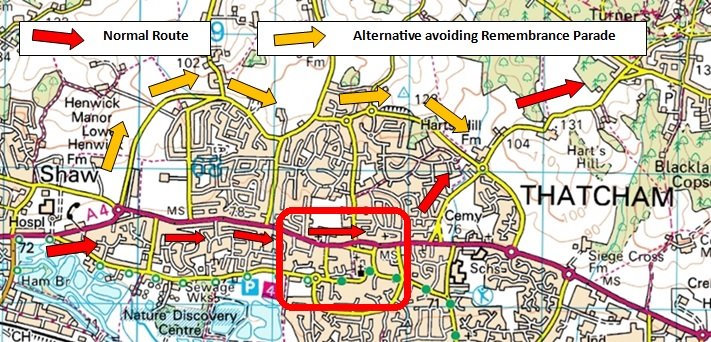
Warning: Remembrance Sunday Road closures in Thatcham 10.30 to 11.30

There are road closures in Thatcham on Sunday morning for Remembrance Sunday - see travel details below

Location:

The car park and event centre are on The Green  at Chapel Row , RG7 6PD. Grid ref: SU571696


Assembly will be on the village field with parking on grass. Please advise the Organiser if you intend to bring a coach.


Travel:

From the EAST turn off the M4 at junction 12, take the A4 West for 2km. At the second roundabout turn right onto the A 340 to Pangbourne.  After 0.5km turn left onto minor road signposted Bradfield. After 2km turn left signposted “Bradfield Southend” and Bucklebury . Proceed for 4km until you reach Chapel Row. Assembly and parking is signposted to the left.

From the WEST and from the A34 BEFORE 10.30 : Leave Newbury going East along the A4 through Thatcham. As you are leaving Thatcham, take a left turn signposted for Upper Bucklebury. Cross roundabout and continue on minor road (via Harts Hill Lane, Broad Lane and the Common)  to Chapel Row where Assembly and the parking is signposted to the right.

Thatcham Diversion AFTER 10.30 At the A4 roundabout on the Western outskirts of Thatcham take the Second turn - Tull Way northward. Straight along Bowling Green road , bear left into Heath Lane. Take next turn right (roundbout) . Left turn at roundabout into Floral Way . at second roundabout turn left into Harts Hill lane. 

Via Harts Hill Lane, Broad Lane and the Common  to Chapel Row where Assembly and the parking is signposted to the right.    

Please do not use the other minor roads – often narrow - running through the area

There is parking charge of £1 per vehicle.

Facilities:

The following facilities are available in the Assembly field:. 

First Aid by HART FIRST RESPONSE, (Registered Charity 1092333). We aim to help save lives by providing ambulance and first aid cover at local events, and by teaching first aid skills within the community. www.hartfirstresponse.org.uk

Ultrasport 

Squash

Toilets

Registration:

Opens at 9.30. 

All Competitors who have pre-entered and have their own Emit e-card should go straight to the Start. 

Start times are between 10:00 and 12:00. 


White and Yellow  course runners  collect their maps at the pre-start.

Note that for simplicity and based on expected numbers we are issuing start times by Start Blocks of 30 minutes   so that you can join the Start queue at any time within the 30 minutes after your start time.

As a result everyone, who is  in the same start block,  will have the same start time  ie 10.00. 10:30, 11:00, 11:30   and for helpers on late runs 12:00. 


EOD

Courses may be entered on the day subject to map availability. Starts are between 10.00am – 12.00pm.

EOD entry is £12.00 for adults if BOF members otherwise £14 and £5.00 for all children .

EMIT hire is £1.50 for Adults.

For pairs and Groups one entry fee is charged  - Additional maps  £1

Courses close at 2.30pm 

All Entries on the day will be given a slip with your entry details – hand this in at the start. 

There is no String course.


Emit Card

Issue and

Return:

Competitors hiring Emit cards should collect them from Enquiries before going to the start. Hired Emit cards will be collected at download. A charge of £45 will be made for lost cards.

NOTE Regarding use of EMIT:

It is the competitor’s responsibility to check that their EMIT card has been registered, including on the back-up card, at each control and the Finish. Reinstatement for missing electronic punches will only be made on visible evidence of the correct pin punch on the back-up card. Hire cards will include back-up card on collection. Spare back-up cards will be available at Registration.

Start

The route to the Start is signposted from the far South–East corner of the parking  field.  There is a   walk of  1 km  to the start and back from the finish – allow  15 minutes. The route is initially along a track and then on a quiet residential road  before turning right along the verge for 30 metres and then take care crossing the minor road (Hatch Lane) and going through the gate. Immediately turn right BEFORE the  house. After 100m the path forks left for the Start  (the Finish is straight on). 

At this point there is an area to leave clothing  but this will be unmanned and so will be used at your own risk 


DO NOT WALK directly down Hatch Lane – there are no verges and traffic is often fast.


The Start is a punching start

Loose description sheets will be available in the start lanes except for the White and Yellow courses.  White and yellow courses must collect their maps and descriptions at the pre-start. 


Road Crossings

The East-West road through the middle of the map is Out-Of-Bounds as indicated with the  purple X  symbol.

This road is only crossed by the Blue and Brown courses at the two compulsory manned road crossing points for your safety.

Please follow the advice from the Marshalls.

There are controls on each side of the road – you must punch both. 

One minute allowance is given for each road crossing


In addition, Green, Blue and Brown courses cross much quieter North-South Roads which are not marshalled .

TAKE CARE in crossing ANY road


White , Yellow and Orange, Light Green, Short Green courses do not cross any roads


Course

Length

Climb

No. controls

Descriptions

White

1.1km

15m

6

Text

Yellow

2.1km

25m

9

Text

Orange

3.2km

30m

11

Text

Light Green

3.7km

40m

11

Pictorial

Short Green

3.6km

40m

11

Pictorial

Green

4.8km

55m

14

Pictorial

Blue

7.1km

150m

24

Pictorial

Brown

9.6km

200m

29

Pictorial

Course Close

Courses closes at 2.30

Finish

There is one finish for all courses . – Squash is available in the Assembly field

Follow  the “Start” route back to the Car park field and the Download tent.

ALL competitors must report to the DOWNLOAD tent  even if they retire. 


Map

Scale 1:10,000, 5m contours, resurveyed 2015 by Katy Stubbs with minor updates in 2017.

Courses and control descriptions will be over printed on waterproof paper 

Terrain

Areas of heathland and mainly deciduous woodland interspersed with dwellings - all with a complex path and track network. Some detailed contours and features on the north side of the map.

There are some extraction lanes, seasonal and animal tracks which are not on the map.

Bracken will be encountered on the Brown, Blue, Green, Short Green and Light Green courses.  Most can be avoided as there are numerous small paths dotted about the area.

There are some areas of bracken in open areas that are not shown on the map.

Some marshes depicted on the map are dry at the moment, but they may get wet if we have rain on the few days prior to the event.


Notes for the Yellow course:

1)TAKE CARE BETWEEN CONTROLS 4 AND 5 AS THERE IS A VERY SLIPPERY WOODEN BRIDGE ACROSS THE STREAM


2)There is an 80m taped route between controls 6 and 7. This is marked with red/white tape. - follow the tapes and through the gate


Bio Security

Please come to the event with clean and dry shoes and clothing. After your run please follow the guidance that helps protect our precious environment:

·         Check

·         Clean

·         Dry

Before leaving the event check your clothing and equipment and remove any mud, soil or leaf litter.

Once home thoroughly clean your footwear and clothing and then leave it to dry for as long as possible. Many invasive non-native species are able to survive in damp corners for very long periods of time, but are less able to survive if the equipment is thoroughly dried.

Photography

The club has designated photographer(s) and details are available from registration. Photographs from the event may be used by the club and made available on the internet in accordance with British Orienteering guidelines. Please speak to a club official at registration if you have any concerns

General

Safety:

- Please take care when crossing and walking along Forest roads. 

- There is public access to Bucklebury Common, please respect the rights of others, particularly the horse riders. 

- Please report to download even if retiring as this will ensure we can check you have returned safely. Competitors travelling alone are encouraged to leave a set of keys at registration. 

- Competitors are advised to carry whistles. 

- Competitors take part at their own risk and are responsible for their own safety.


Accidents:

- First Aid by Hart First Response in Assembly field


-Accident and Emergency unit :

A&E
Royal Berkshire
NHS Foundation Trust
Centre Block
Craven Road
Reading
RG1 5AN

0118 322 7020

Officials

Planner: Andy Parry

Organiser: Simon Moore 07796 953733

Email: events@bko.org.uk 

Controller: Andy McGregor  (BADO)


IMPORTANT OFFICIAL NOTICES:

  • Competitors take part at their own risk
  • The personal data you give will be used by the event organisers only for the purpose of processing/publishing entries and results and as required by our insurers. Entry details will be stored in a computer. Submissions of an entry for the event will indicate your acceptance of this procedure.
  • In the event of cancellation of the event, part, or all of your entry fee may be retained.
  • The club has designated photographer(s) and details are available from registration. Photographs from the event may be used by the club and made available on the internet. Please speak to a club official at registration if you have any concerns.

Level C Colour Coded Event (Black Park Country Park) 21-May-17 - Final Details

Sunday 21st May

Black Park, Slough

LEVEL C SCOA LEAGUE EVENT

Final Details

Berkshire Orienteers welcome you to the event!

Travel:

Grid Reference: TQ005832 Nearest Postcode: SL3 6DT

The event will be signed from the A412 Uxbridge Road approximately 2 miles North of the junction with the A4. The final approach along Black Park Road is narrow and potholed. Be aware that some satnavs may direct you beyond the park entrance, however this is clearly signed.

Parking:

Parking is in the public car park at Black Park Country Park. This is a Pay and Display car park – fees for cars are £3.50 and £7.50 for Minibuses (Blue badge holders – free). Be aware that the parking wardens can be very active (as the Organiser knows to his cost!).

Assembly:

The Assembly and Registration area is at TQ 009 835, approximately 250m from the car park. Take the major path NW from the car park, passing Go Ape on your left and the refreshment kiosk on the right. After 200m turn left at a major junction and Assembly will be visible on the right. The route will be taped.

Dogs:

Allowed but must be under control at all times and on a lead in Assembly area.

Planners Notes:

Black Park is a country park consisting mainly of mixed woodland with a good path network. The area is fairly flat, with little climb on any course. There is a substantial area of open heathland in the NE part of the park - this is out of bounds as it is a SSSI. The tracks within the OOB can be used. The Green, Blue and Brown courses do go along tracks through it to get to the Northern end of the park - please keep to the tracks. There are other SSSI’s within the woods, also marked as out of bounds, most of which are very wet marshes. Please respect all of these - unfenced ones are not taped but are easily avoided by all courses. 

Some large depressions that have been mapped as containing water are not filled with water due to the dry spring.

There are some areas where the heavy undergrowth is high - courses have been planned to avoid the worst of these.  

There are quite a number of hides in the woods which have not been mapped. 

There is a woodchip pile in the area which are mapped as out of bounds - please do not climb on or attempt to cross it.

White and Yellow courses have some decision points that are not covered with a control. Smiley faces are used to guide them along the correct route.

Map:

Waterproof A4 map. Scale 1:10,000, 5m contours, surveyed in September/October 2014 and updated in March/April 2017. Map updates by Katy Stubbs and Alan Kersley.

The Brown course has a double-sided map. On reaching the last control printed on the first side of the map, turn the map over - that control will be depicted on the reverse as a start triangle. All other courses have a single sided map.

Control descriptions are on the map. White and Yellow courses use text descriptions; all other courses use IOF symbols.

Special symbols are used on the map:

 O represents a seat or picnic table

Courses

White to Brown (no string course)

Course

Length

Climb

No. controls

Descriptions

White

1.8km

5m

10

Text

Yellow

2.2km

5m

10

Text

Orange

3.2km

5m

10

Pictorial

Light Green

3.6km

15m

12

Pictorial

Short Green

3.6km

15m

12

Pictorial

Green

5.1km

20m

14

Pictorial

Blue

7.2km

25m

17

Pictorial

Brown

9.9km

35m

23

Pictorial

Starts:

Start times 10:30  – 12.30.  Start blocks (30 minute) will be pre-allocated on Fabian4 so please check the start list there.  Blank maps and control descriptions will be available in the start lanes. All starters must check their EMIT card using the MTR0 device as this provides a record of who is in the forest for safety purposes.

The Start is about 450m walk from Registration. The route will be taped. No clothing dump.

Competitors who have pre-entered with their own EMIT cards may go straight to the Start.

White and Yellow course maps can be collected at the pre-start so competitors may review them before starting their course.

Finish:

The Finish is approximately 300m from Assembly along a taped route.

Courses close at 14:00. Please ensure that you download even if you have not finished so that we don’t send out a search party.

Safety Notices:

The park will be busy on Sunday – please be aware of other park users, in particular dog walkers, mountain bikers and Segway riders, and avoid moving vehicles in the car park. Parents are advised to take particular care of children in the car park, around Go Ape equipment and near the lake. There is also a major road (out of bounds) along one side of the Park.

Full arm and leg cover is required and cagoules may be required if the weather is bad.  A whistle is advisable. It may be warm on the day so please ensure you bring a personal supply of water to keep hydrated.

All competitors are advised to check body and clothing for ticks after the event. There have been occasional reports of adders in the Park, mostly on the heath area (out of bounds). Cattle are likely to be grazing on the heath area.

The nearest A&E is at Wexham Park Hospital, Wexham, Slough, Berkshire, SL2 4HL.  Tel  01753 633000.

Facilities:

There will be toilets and first aid. There is a refreshments kiosk and a café within the park.

Entries:

Online entries are available via Fabian4, www.fabian4.co.uk, until midnight on 18th May.  Please enter online if at all possible.

Entry on the day is available subject to map availability.  Registration for EOD is from 10:00 to 12:00.

Fees:


Entry via Fabian4 by 18th May & EOD

EMIT hire

BOF Senior

£13

£1.50

Non-BOF Senior

£15

£1.50

Seniors on White, Yellow & Orange

£7

£1.50

Junior & Student

£5.00

Free

Electronic Punching:

EMIT electronic punching will be used with a punching start. 

Lost EMIT cards will be charged at £45.

Photography

The club has designated photographer(s) and details are available from registration. Photographs from the event may be used by the club and made available on the internet in accordance with British Orienteering guidelines. Please speak to a club official at registration if you have any concerns

Officials

Organiser: Colin Godbold (BKO) events@bko.org.uk

Planner: Annika Greenwood (BKO) events@bko.org.uk

Controller:Alan Kersley (BADO)

IMPORTANT OFFICIAL NOTICES:

  • Competitors take part at their own risk
  • The personal data you give will be used by the event organisers only for the purpose of processing/publishing entries and results and as required by our insurers. Entry details will be stored in a computer. Submissions of an entry for the event will indicate your acceptance of this procedure.
  • In the event of cancellation of the event, part, or all of your entry fee may be retained.
  • The club has designated photographer(s) and details are available from registration. Photographs from the event may be used by the club and made available on the internet. Please speak to a club official at registration if you have any concerns.

Compass Sport Cup (Cold Ash) 12-Mar-17 - Final Details

Sunday 12th March 2017

Cold Ash , Hermitage

CompassSport Cup and Trophy Heat - Level B

Final Details - remaining maps for EOD courses are limited

Berkshire Orienteers welcome you to the event!

Travel & Parking:

Parking and assembly are in a field on the south side of Everington Lane/Yattendon Road at GR SU519736 nearest postcode is RG18 9XP

The event will be signposted from the B4009 in Hermitage at the junction with Yattendon Road.

Please do not use the other minor roads – often narrow - running through the area.

There is a £1 parking fee for the use of the parking and assembly field.

We will be using tracking at the field entrance - NO vehicles larger than 17 seater minibus please

Assembly:

The Assembly area holds:

Registration tent

Enquiries/Emit Collection tent

Download/Results tent

Finish

Area for Club Tents

Squash & Water

First Aid

Toilets


Route to the Start: (500 metres) Use the temporary stile in the South East corner of the Assembly field  

Facilities:

Toilets

First Aid by HART FIRST RESPONSE

Squash

Unfortunately it has not been possible to arrange a refreshment van 

Dogs:

Please keep your dogs on leads at assembly and clear up after them. Dogs (under strict control)  are welcome in the woods

SAFETY NOTICES

  • All courses from 1 to 7 (Brown to Veteran Short Green) cross minor roads. Visibility varies according to where you cross.  There will be no manned crossings.  Please be alert to local traffic which can be fast at times. 
  • Full leg/body cover is required for all competitors (UK Rules of Orienteering)
  • Whistles are advised for this event
  • In the event of inclement weather cagoules may be required. This will be notified at registration and at the exit from the field
  • Lone travellers are asked to leave their car keys with Registration with a note of their name
  • If you have a medical problem please complete the confidential forms for use by First Aid (forms at Registration)
  • Safety Bearing is Due North – contact Phone number  07814 938057

CompassSport Cup & Trophy Competition

  • Courses 1 to 9B are dedicated to the CompassSport competition
  • Club Captains must ensure that they have paid their team entry fees either by Bank transfer by 6pm Friday 10th or by cheque payable to “Berkshire Orienteers” handed to Enquiries on Sunday before 10.30
  • Any issues or changes should be referred via your Club captain to the Enquiries team. 

Registration and Entries on the Day:

EOD Registration will be open from 0930 and 1145 - please complete the entry form

Entry to CompassSport Cup and Trophy courses has CLOSED – minor amendments are permitted up to Tuesday 7th March (courses 1 to 9B)

On the day you can only enter Light Green, Yellow or White courses - subject to map availability. (courses 10 to 12).

Remaining maps: Light Green 22, Yellow 9, White 5 

  • Seniors - £9 on Light Green, £6 on White and Yellow
  • Non-BOF Seniors - £11 on Light Green , £8 on White and Yellow
  • Juniors - £4
  • For pairs and Groups one entry fee is charged  - Additional maps  £1
  • EMIT hire fee £1.50 for Seniors –(free for Juniors)

Lost EMIT cards will be charged at £45.

All Entries on the day will be given a slip with your entry details – hand this in at the start.

Competitors on all courses will collect their maps at the Start, although White and Yellow Course runners will be able to study their maps before starting.

Lone travellers are asked to leave their car keys with Registration with a note of their name (envelopes will be provided)

MEDICAL DETAILS  

If you have a medical problem please complete the British Orienteering Medical form at Registration or else click on this link  to download the form.  There will also be forms and envelopes at Registration.  The envelope can either be handed to the Registration team or to the 1st Aid team.  After the event, if not collected, it will be destroyed unread. 

Enquiries

Club Captains should refer any problems with CompassSport entries to the Enquiries team

Emit Card

Issue and

Return:

EMIT collection will be between 0930 and 1215 from the Enquiries/EMIT Collection tent

Note that Lost EMIT cards will be charged at £45.

There will be spare backup cards for those with their own EMIT cards at Enquiries.

There will be a demonstration EMIT control near to Enquiries

Hired Emit cards will be collected at download.

NOTE REGARDING THE USE OF EMIT:

It is the competitor’s responsibility to check that their EMIT card has been registered, including on the back-up card, at each control and the Finish. Reinstatement for missing electronic punches will only be made on visible evidence of the correct pin punch on the back-up card. Hire cards will include back-up card on collection. Spare back-up cards will be available at Registration.

Course

Colour

Classes

Length km

Climb m

No. Controls

Map size

1

Brown  

Men Open

10.4

250

28

A3

2

Short Brown

M40+, M20-

9.0

210

23

A3

3

Blue - Women

Women Open

7.4

190

18

A3

Blue - Men

Men M50+

7.6

160

16

A3

5

Green - Women

Women W45+ W20-

5.1

105

13

A3

6

Green - Men

Men - M60

4.9

120

14

A3

7

Veterans Short Green

M70+ W60

3.7

80

12

A3

8A

Junior Men Green

M18-

5.0

140

17

A3

8B

Junior Women Short Green

W18-

3.6

100

11

A3

9A/B

Orange

M14- W14-

2.7

60

10

A3

10

Light Green


3.7

75

12

A3

11

Yellow


1.8

20

11

A3

12

White


1.1

15

8

A3

Map

The map scale is 1:10, 000 with 5 m contours and minor updates have been made to reflect current forest conditions (up to the end of February 2017).

Courses are printed at A3.

The following special symbols are being used and will be shown on the competition maps:


Feature

Map Symbol

Pictorial description

Rootstock

Brown

X

IOF 

Distinctive tree

Green

O

IOF

Small shooting tower

Black T

T

not used

Manmade feature - Water tank

Blue circle

O

not used

Manmade feature – scrap metal

Black circle

O

not used

Maps do not have a full legend, only non-ISOM and special symbols are shown.

Mapping: The MapWorks  2012/13 ; updated 2014 and February 2017.

Control Descriptions

  • Orange to Brown courses will have pictorial descriptions printed on the map. 
  • White and Yellow courses will have text descriptions printed on the map. 
  • Loose pictorial control descriptions on waterproof paper will be available in the start lanes for all courses.  

Terrain

Mixed, mainly deciduous, woodland with generally good runnability except where forest thinning has taken place in the last couple of years which has resulted in localised patches of brashings and brambles.  The area has several gently sloping hills and a fairly extensive path network.

Forestry thinning operations were continuing in the south west of the area as the maps went to print and this may affect Blue to Brown courses.  

The green-striped ‘slow run undergrowth’ screen has been used where brashings from forestry work affect runnability as well as for bramble patches.  Forestry extraction lanes are mapped as rides where significant, but not all may have been mapped.  Wherever possible, courses have been designed to avoid the worst of the brashings.  The forestry operations have also churned up some of the main tracks and rides.

The original map included many rootstocks. Some have decayed and either resemble
knolls or are barely discernible. Other new ones have been created. We have amended the map suitably around control sites, and those that are used as control features are clear,
but it would be unwise to rely on rootstocks for
navigation.

Some large depressions are now full of water; many of the wide rides are very muddy and slow. In general, the forest and small paths offer better running than larger paths and rides. Wellies would be a good idea for those walking round the white and yellow courses.

Additional safety warning/information

 The longer courses (Veteran Short Green to Brown) cross minor roads – Take care - there will be no manned crossings

(Junior CSC courses, and White and Yellow EOD do NOT cross any roads)

Start

The same start is used by all courses. It is 500m from Assembly – leave the field via the stile in the South-East corner of the field

The event uses EMIT electronic timing with a punching start

Pre-entered competitors with their own EMIT cards can go directly to the start. Hire EMIT cards (and back up cards) can be collected from the Enquiries/EMIT Hire tent.

Start times 10:25 to 12:30.

Start Times will be adhered to - Make sure that you arrive at least 5 minutes before your start time

Warning:  Some courses are fairly full.  As we have to keep a minimum of 4 minutes between start times for members of the same club, so if you are late for start time, you may have to wait until 12:30 before you get your run.

Loose control descriptions will be available in the Start lanes.

When you start, place your EMIT card flat on the start control and check that the light flashes  

Finish

The run-in and Finish are in the assembly field.

Please remember to download AS SOON AS YOU FINISH  at the Download/Results tent

Water and Orange Squash will be available near to download.

Course Close

Courses closes at 2.30

TAKE CARE OF THE WOOD

Please come with clean shoes and running clothes.

After your run clean off any mud and wood debris.  Once home clean and dry your kit thoroughly

First Aid and A&E:

Assembly Field: Ambulance and First aid will be provided by Hart First Response (Registered Charity 1092333) www.hartfirstresponse.org.uk


The nearest A&E is:

Royal Berks        (12.8 miles)

London Road

Craven Road

Reading

Berks

RG1 5AN

0118 322 5111


Minor Injuries Unit (5.8 miles)
West Berkshire Community Hospital , London Road, Benham Hill
Thatcham , Berkshire 
RG18 3AS


Phone: 01635 273 508

Officials

Planner: Mark Foxwell

Organiser: Peter Entwistle  07814 938057

Email: events@bko.org.uk

Controller: Roger Thetford (TVOC)

IMPORTANT OFFICIAL NOTICES:

  • Competitors take part at their own risk
  • The personal data you give will be used by the event organisers only for the purpose of processing/publishing entries and results and as required by our insurers. Entry details will be stored in a computer. Submissions of an entry for the event will indicate your acceptance of this procedure.
  • In the event of cancellation of the event, part, or all of your entry fee may be retained.
  • The club has designated photographer(s) and details are available from registration. Photographs from the event may be used by the club and made available on the internet. Please speak to a club official at registration if you have any concerns.

Concorde Chase (Hawley and Hornley) 29-Jan-17 - Final Details

Sunday 29th January

Concorde Chase - Level B Event

Hawley and Hornley


Final Details 

Berkshire Orienteers welcome you to the 2017 Concorde Chase

Key Points:

  • Postcode GU17 9UD, GR SU830574 then a further 2km drive to event parking area/assembly 
  • All courses cross the access road twice (except White, Yellow and Orange), Competitors to take care crossing access road and vehicle drivers to drive slowly, heed the warning signs and give way to runners 
  • £1 per vehicle parking fee
  • Registration/Entry on Day open 1000 to 1200
  • Start times - 1030 to 1230 - (300m walk to the start from Assembly)
  • Course closes 1430
  • Waterproof maps A3 or A4, scale 1:10,000
  • EMIT electronic timing
  • Ultrasport/Burger Van/Toilets/First Aid at Assembly

Travel:

The nearest postcode to the event is GU17 9UD GR SU830574, access to the area will be through Hawley Sailing club car park and into the forest.

1.  From the North: At the A30 junction with the A327 turn South onto the A327 (Minley Road). At the next roundabout take the 1st exit (still Minley Road).  After just under 2km there will be a sign for Hawley Sailing Club on the left - turn left here and follow the road to Hawley Sailing Club car park (1km).

2.  From the M3:

From the London bound M3 - at Junction 4A take the sliproad left to the A327 towards Farnborough (W)/Fleet.  At the next roundabout take the 2nd exit on to the A327 Minley Road. 

From the Basingstoke bound lane - at Junction 4A take the sliproad to Farnborough (W)/Fleet and then the filter lane left at the next roundabout onto the A327. At the next roundabout take the 1st exit into the A327 Minley Road.  

Both - After 1km the entrance to Hawley Sailing Club will be on your right. Turn right and follow the road to Hawley Sailing Club car park (1km).

All traffic

There are speed bumps on the road to the sailing club, please drive slowly as there may be competitors crossing the road near to the junction.

At the end of the car park is a gateway onto the access road.

There is parking charge of £1 per vehicle that will be collected at this gateway.

Parking for this event is a further 1km into the forest - please drive slowly as there may be runners crossing this road.  Once you reach the Assemby area park as directed by the Parking Team.

Important Safety Information:

This is a military training area. DO NOT pick up anything you did not drop. A number of control sites are pits which have iron stakes around the edges. You may encounter  odd strands of  barbed wire. Take care.

- The access road to and from the carpark is crossed twice by all courses other than White, Yellow and Orange. There are no fixed crossing points, but there will be marshals along the access road. Drivers should drive slowly, heed the warning signs and  give way to runners.

Some courses cross the routes to the Start and from the Finish. Please give way to runners heading for their final controls.

- Please take care when crossing and walking along Forest roads.

- There is public access to Hawley and Hornley commons, please respect the rights of others, particularly the horse riders, dog walkers and mountain bikers.

Please report to download even if retiring as this will ensure we can check you have returned safely. Competitors travelling alone are encouraged to leave a set of keys at registration.

- Competitors are advised to carry whistles.

- Competitors take part at their own risk and are responsible for their own safety.

- The organisers reserve the right to insist that cagoules are carried in the event of bad weather.

Facilities:

The following facilities are available at Assembly:

First Aid by HART FIRST RESPONSE, (Registered Charity 1092333). 'We aim to help save lives by providing ambulance and first aid cover at local events, and by teaching first aid skills within the community'. www.hartfirstresponse.org.uk

Ultrasport

Continental Catering with the lovely Tom and the even lovelier Julie

Toilets

Please bring your own drinks/water - water/squash will not be provided at the finish.

Dogs:

It is a condition of the licence granted to hold this event that any dogs brought onto the area must be on a lead at all times.

Please ensure you clear up after dog.

Registration/EOD:

Entry on the day and Hired EMIT collection between 10:00 and 12:00

Competitors who have pre-entered and have their own Emit e-card can go directly to the Start.

Start times are between 10:30 and 12:30.

Individual start times will be published on Fabian 4 and displayed at the Start and Registration.

Please note that the Green, Short Blue and Blue courses are very full with pre-entered competitors.  If you are on one of these courses please try your best to stick to your start time or there may be a long wait before the start team can fit you in.

Courses may be entered on the day subject to map availability (note the above comment regarding Green/Short Blue/Blue courses. EOD entry is £16.50 for adult BOF members,  £18.50 for Non BOF members and £6.00 for juniors.

For pairs and Groups one entry fee is charged  - Additional maps  £1

All Entries on the day (and course changes on the day) will be given a slip with your entry details – please hand this in at the start.

Courses close at 14:30

EMIT Card Issue and Return:

Competitors hiring EMIT cards should collect them from Enquiries before going to the start.  Hired EMIT cards should be handed back at Download.  A charge of £45 will be made for lost cards.

Spare back-up cards will be available from Enquiries for those with their own EMIT cards.


Medical Conditions:

Any competitors with a medical condition that might require medical assistance during the event are invited to complete the medical form from the BOF website (https://www.britishorienteering.org.uk/handbook_safety - select 'medical form' from the documents list), complete it and leave it in a sealed envelope with Enquiries.  It will be shredded after the event.  

Blank copies of this form and envelopes will be available at Enquiries if necessary.

Start

The Start is 300m walk from Assembly area and will be a punching start although start times will be given on Fabian4.

Call up will be at minus 4 minutes.

Late starters may have to wait for a time-slot to become available on busy courses.

Loose description sheets will be available in the start lanes.

Road Crossings

Most of the senior courses will cross the access road to parking/assembly. 

Please follow the advice from the Marshalls. 

TAKE CARE in crossing ANY road

White , Yellow and Orange courses do not cross the access road but do cross other roads within the area.  There will be no event traffic on these roads but there may be other vehicles but they will be travelling slowly.

Please take particular care if driving out of the area via the access road before the course closes

Course

Age Categories

Length

Climb

No. controls

Descriptions

Paper Size

White

M10B W10B

1.7km

35m

13 

Text

A4 

Yellow

M10 W10 M12B W12B

2.7km

55m

13 

Text

A4 

Orange

M12 W12 M14B W14B

3.2km

65m

 14

Text

A4 

Light Green

M14 W14 M16B W16B

3.8km

80m

 10

Pictorial

A4 

Very Short Green

W75 W80 W85 W90 M70S M75S M80S M85S W55S W60S W65S W70S

3.3km

85m

 12

Pictorial

A4 

Short Green

M75 M80 M85 M90 W65 W70 M65S W18S W20S  W45S W50S

4km

90m

 11

Pictorial

A4 

Green

M70 W16 W55 W60 M55S M60S W35S W40S

5.2km

95m

 14

Pictorial

A4 

Short Blue

M65 W18 W20 W45 W50 M20S M50S M45S W21S

6.1km

105m

 17

Pictorial

A4 

Blue

M16 M55 M60 W35 W40 M35S M40S

7.7km

150m

 21

Pictorial

A4 

Short Brown

M18 M20 M45 M50 W21 M21S

9.4km

140m

 22

Pictorial

 A3

Brown

M35 M40

11.4km

160m

 31

Pictorial

 A3

Black

M21

13.4km

220m

 35

Pictorial

A3 

Course Close:

Courses closes at 14:30

Finish:

There is one finish for all courses and is approximately 500m from Assembly. 

Follow the marked route back from the Finish to the Car park and the Download tent.

ALL competitors must report to the DOWNLOAD tent even if they retire.

 Map: 

Scale 1:10,000, 5m contours, updated December 2016 by Roger Maher.  Courses and control descriptions will be overprinted on waterproof paper.

The A4 maps for the White, Yellow and Orange courses have a partial legend.  The A4 maps for courses Light Green to Blue do not contain a legend.  The legend on the A3 Black course map is partially obscured by the control descriptions.

A full legend can be viewed at Assembly.

Planners Comments:

Terrain

Hawley and Hornley (H&H) consists of areas of forest and open heathland extending from an East-West ridge North to the A30, and South to Hawley Lake and beyond.

The forest area is generally runnable, although, in places, there are clumps of rhododendrons and bracken which has not died back in early January.  The light undergrowth symbol has been used to indicate the main areas of bracken and undergrowth such as brambles.  A few blocks mapped as "forest", contain both mature trees and coppice.  The forest area is crossed by networks of paths and tracks, but recently formed mountain bike trails are not mapped.  There is a well-contoured re-entrant in the North-East of the forest, and an open out-of-bounds area close to the start.

In parts of the heathland areas, there might appear to be more gorse than the map suggests.  However there are passable routes through the gorse.  The gorse is indicated by green "forest fight" or undergrowth screens.

In the South West, there is a large open area of heathland containing gorse, heather, tussocky grass and some marshes.  This zone is surrounded by a 5 foot high barbed wire fence to enclose a few grazing cattle.  Access to this zone is via cattle grids and stiles.  Two stiles close to optimum routes are highlighted on the map and will be taped.

The second heathland area is in the North, dipping gently towards the A30.  It too, contains heather, gorse and marshes, as well as a few blocks of forest.  The representation of gorse on the map was acceptably accurate in early January.  However Hants and Isle of Wight Wildlife Trust (HIOWWT) who manage the environmental aspects of the area for the MOD, are clearing scrub and burning gorse.  Some of this work involves mowing tracts of grass and clearing heather down to soil level to improve the environment for reptiles.  Only a few of these "scrapes" have been mapped, usually in the vicinity of control sites.  They are mapped with the yellow "open ground" screen.

Any major changes to the heathland which occur after the maps have been printed will be displayed in the start lanes.  There may be some clearing work taking place on the day of the event but this should not be near controls.

There is an Army Permanent Orienteering Course (POC) at Hawley and Hornley.  Some control sites are shared with the POC.  Please ignore the codes on the POC stakes.

Vandalised or Missing Controls

Previous events at H&H have suffered from vandalised controls.  Control site tags (red electrical tape) have the control code e.g. "213", and a 2nd three letter code e.g. "DOG". If you think you are in the correct place and there is a tag but no control, please note the 2nd code to confirm you have been there.

 Special Symbols

The symbol 'X'represents a hide on both the map and the control descriptions.

The symbol   has been used to represent a horse jump.

Bio Security:

Please come to the event with clean and dry shoes and clothing. After your run please follow the guidance that helps protect our precious environment:

·         Check

·         Clean

·         Dry


Before leaving the event check your clothing and equipment and remove any mud, soil or leaf litter.

Once home thoroughly clean your footwear and clothing and then leave it to dry for as long as possible. Many invasive non-native species are able to survive in damp corners for very long periods of time, but are less able to survive if the equipment is thoroughly dried.

Photography:

The club has designated photographer(s) and details are available from registration. Photographs from the event may be used by the club and made available on the internet in accordance with British Orienteering guidelines. Please speak to a club official at registration if you have any concerns.

Accidents:

First Aid by Hart First Response in Assembly field 

Accident and Emergency unit :

Frimley Park Hospital (2.2 miles away - open 24 hours)

Portsmouth Road

Camberley 

GU16 7UJ

tel. 01276 604604

Important Information:


Safety and Risk:  A comprehensive risk assessment has been carried out by the organiser and is available on request but participants take part at their own risk and are responsible for their own safety during the event.

Insurance:  Please note that if you have competed in three orienteering events registered with British Orienteering and not joined an orienteering club which is a member of British Orienteering then you are NOT covered by British Orienteering public liaibility insurance.

Cancellation: Whilst cancellation is a last resort, if very bad weather is forecast or some unforseen event makes it necessary to cancel this event, a notice will be placed in the BKO website.  If the event has been cancelled then BKO reserve the right to retain part of the entry fee to cover unavoidable costs.  Please check our website for any last minute information before you travel to the event.

www.bko.org.uk

Officials:

Planner: Richard Rae

Organisers: Fiona Clough (07719-590542) and Eoin Sharkey (07957 801673)

Email: events@bko.org.uk

Controller: Andy Robinson (SLOW)


Many thanks to DIO and Landmarc for allowing us to use this area for our event and to Hart First Response for providing medical cover. 

IMPORTANT OFFICIAL NOTICES:

  • Competitors take part at their own risk
  • The personal data you give will be used by the event organisers only for the purpose of processing/publishing entries and results and as required by our insurers. Entry details will be stored in a computer. Submissions of an entry for the event will indicate your acceptance of this procedure.
  • In the event of cancellation of the event, part, or all of your entry fee may be retained.
  • The club has designated photographer(s) and details are available from registration. Photographs from the event may be used by the club and made available on the internet. Please speak to a club official at registration if you have any concerns.

Level C Colour Coded Event (Greenham Common) 30-Oct-16 - Final Details

Joint BKO/BADO

Greenham Common Weekend

29th October - Level C Night Event

30th October - SCOL2 (SCOA League) – Level C Event

(with SCOA League 2015/16 Prize Giving)

FINAL DETAILS

BKO and BADO welcome you to a weekend of orienteering at Greenham Common, Newbury.
The weekend starts with a Night Event on Saturday evening and is followed on Sunday morning by a level C SCOA League event which will include the SCOA League prize giving for 2015/16.

NOTE: CLOCKS GO BACK 1 HOUR at 2am on Saturday night

Information Common for Both Events

Parking/Assembly: Parking is adjacent to assembly on hard standing in the north-western most car parks of the Greenham Business Park (GR SU495646). Access into the business park can only be through the eastern entrance to the business park on the A339 roundabout (RG19 6HP - GR SU503638) past the security building then follow the O-signs to parking/assembly. Please note the entrance onto the Business Park off the nearby western roundabout is closed to traffic at weekends.

There is a £1 parking fee payable both on Saturday evening and Sunday. All money collected is going to the Greenham Common Trust, the charitable organisation that runs the business park.

Maps and area: The Map is 1:10,000 on A4 waterproof paper, 5m contours and has been updated for this event. The mostly deciduous area of Crookham Common contains some contour detail and undergrowth as well as a good path network. The old quarry area in the northeast is complex in part and contains water features. The longer technical courses will, this weekend, be visiting the mainly undulating terrain in the eastern half of the area, which has gorse and some ground detail in sections across the former airfield.

Control Descriptions

Control descriptions are printed on the maps. Loose control descriptions will be available in the start lanes. White, yellow and orange courses use text descriptions; all other courses use IOF symbols.

Assembly

Assembly (and the Maze on Sunday) will be located on the grass area adjacent to the parking area. From Assembly there is a small gravel path leading out onto the common and the starts for both days.

Facilities

Tom’s Wagon (Sunday only), Ultrasport (Sunday only) and portable toilets (both days) will be located on the hard standing a short distance from assembly.

Water

Water will be available near to download.

First Aid

Ambulance and first aid at both events will be provided by Hart First Response (Registered Charity 1092333) www.hartfirstresponse.org.uk

The nearest hospital is Basingstoke and North Hampshire Hospital, Aldermaston Road, Basingstoke, RG24 9NA (01256 473 202) – 9.7 miles or Royal Berks, London Road, Reading, Berks, RG1 5AN (0118 322 5111) – 20 miles.

Dogs

Please keep your dogs on leads at assembly and clear up after them. Dogs are not permitted on the courses on the night event but welcome (under strict control) at the Sunday event.

Enquiries/Entry on the day/EMIT hire: Pre-entry through Fabian4 (http://www.fabian4.co.uk) remains open for late entries close on midnight Tuesday 25th October. There will be limited EOD subject to map availability. There is a £2 discount to seniors and a £1 discount to juniors entering both Saturday night and the Sunday morning event online.

Officials

Planner – Night: Bernie Fowler BADO

Planner – Day: Andy Macgregor BADO

Organisers: Fiona Clough/Peter Entwistle BKO

Controller: Eric Harper BKO

Mapper: Alan Kersley BADO


Saturday 29th October – Night Event

SUMMARY

  • Electronic punching – EMIT
  • No spare torch and whistle – no go
  • Green Glow Sticks – Assembly to Start (200m)
  • Check your name off the list at the start
  • Control Descriptions in start lanes
  • Start time 1830 to 1930
  • Blue Glow Stick on the start kite
  • Blue Glow Stick indicates the Finish
  • Red Glow Sticks – Finish back to Assembly
  • Traders: NO Burger Van on Saturday  (just available on Sunday)
  • Course closes at 2100
  • REMEMBER TO DOWNLOAD PLEASE!

SAFETY and COURSE NOTICES

A spare torch and whistle must be carried by all competitors and will be checked at the start - No whistle and spare torch - No go. A safety phone number is on the map. Mobiles are not compulsory but if you take one make sure it is in a secure pocket.

In the event of inclement weather cagoules may be required. This will be notified at registration.

Wildlife (cows and ponies) may be roaming the common, please try and avoid them. There are numerous thickets and undulations - take care. The longer courses go in to the NE area of the map. Water levels are continually changing and competitors are to consider this when deciding whether to cross areas marked as seasonal / marsh. There are other route choices available. There are three water features with black borders on the map in the NE area and these are NOT to be entered. There is also a steep slope that is fenced off and must be avoided. The vegetation in the NW area has been mapped as well as can be but may be thicker than advertised on the map.

Registration

EOD and EMIT collection will be between 1800 and 1900.

On the day registration will be subject to map availability. All entries on the day will be given a slip of paper with your entry details to take to the start with you and hand in.

Seniors - £12 / Non-BOF Seniors - £14 / Juniors - £5 (please note juniors under 16 must be shadowed

or accompanied by an adult for this event – BOF insurance requires this)

EMIT hire fee £1.50 Lost EMIT cards will be charged at £45.

Lone travellers are encouraged to leave their car keys and emergency contact details with Enquiries (envelopes will be provided).

Courses

The final course lengths are as follows:

  • Orange 1.7km
  • Light Green 3.3km
  • Green 4.4km
  • Blue 5.6km
  • Brown 6.5km

Climb for all courses is less than 20m.

Start and Finish

Start times 1830 to 1930.

Pre-entered competitors with their own EMIT cards can go directly to the start. Hire EMIT cards (and back up cards) can be collected from Registration. We are not allocating start times, just turn up and run.

The start is 200m from Assembly. Green glow sticks will mark the route to the start from Assembly. There will be a blue glow stick on the start kite.

The finish is 200m from Assembly and a blue glow stick will be atop the finish flag and Red glow sticks lead from the finish back to download. The area has good paths on the map to help you back to download and assembly if needed. Please remember to download at the earliest opportunity when you finish.

Course Closure

Closure time for all courses is 2100 – all competitors MUST have reported to download by that time, whether or not they have completed their courses otherwise a missing competitor search will be initiated.


Sunday 30th October – SCOL2 (SCOA League) Level C Event
(with SCOA League 2015/16 Prize giving)

SUMMARY

    • SCOA League Prize giving at 1300
    • Electronic Punching – EMIT
    • Control Descriptions in Start lanes
    • Start 650m from assembly
    • Start times – 1000 – 1200 (start blocks)
    • Course closes at 1400
    • Maze at Assembly
    • Traders: Ultrasport, Tom’s burger van.

SCOA League 2015–16 Prize Giving
Prizes will be given out for the 2015 – 2016 SCOA League at 1300.

Registration

EOD and EMIT collection will be between 0930 and 1130.

On the day registration will be subject to map availability.

    • Seniors - £12
    • Non-BOF Seniors - £14
    • Juniors - £5

EMIT hire fee £1.50 Lost EMIT cards will be charged at £45.

Lone travellers are encouraged to leave their car keys with Enquiries.

White and Yellow Course runners must collect their maps from Registration.

Courses

The final course details are as follows:

Course

Length

Climb

No. controls

White

1.6km

Nil

7

Yellow

2.2km

Nil

10

Orange

2.9km

5m

10

Light Green

3.9km

15m

10

Short Green

4.0km

40m

10

Green

4.9km

40m

16

Blue

7.1km

75m

21

Brown

9.1km

100m

35

Start and Finish

Start times 1000 to 1200. Note that start times will be issued in 40-minute blocks. You can go to the start at any time within 40 minutes of your start time so if your start time is 1040 you can start any time between 1040 and 1120.

Pre-entered competitors with their own EMIT cards can go directly to the start. Hire EMIT cards (and back up cards) can be collected from the Enquiries/EMIT Collection tent.

The start is 650m from Assembly. There are two different finishes – the finish for Yellow and White courses is approximately 450m from assembly. The finish for all other courses is 900m from assembly.

Please remember to download at the earliest opportunity after you finish.

Maze

There will be a Maze set up next to Assembly. There will be several courses and it is free. Have a go if you have a spare few minutes, in fact, have several goes if you have the time.

Course Closure

Closure time for all courses is 1400.

Acknowledgements

We would like to thank Berkshire, Buckinghamshire & Oxfordshire Wildlife Trust (BBOWT) for giving us permission to hold this event on the common.


Many thanks also to the Greenham Common Trust who gave us permission to use the Business park for parking and Assembly.


IMPORTANT OFFICIAL NOTICES:

  • Competitors take part at their own risk
  • The personal data you give will be used by the event organisers and their agents only for the purpose of processing and publishing the event entries and results online, for conducting safety checks and to validate British Orienteering insurance cover. Submission of an entry for the event will indicate your acceptance of this procedure.
  • A BKO Registered photographer may be taking photographs in line with the BKO Photographic policy. For details, see: http://www.bko.org.uk/photography
  • In the event of cancellation of either of these events, part, or all of your entry fee may be retained.

Night Event (Greenham Common) 29-Oct-16 - Final Details

Joint BKO/BADO

Greenham Common Weekend

29th October - Level C Night Event

30th October - SCOL2 (SCOA League) – Level C Event

(with SCOA League 2015/16 Prize Giving)

FINAL DETAILS

There is now NO Burger van on Saturday (just Sunday)

BKO and BADO welcome you to a weekend of orienteering at Greenham Common, Newbury.
The weekend starts with a Night Event on Saturday evening and is followed on Sunday morning by a level C SCOA League event which will include the SCOA League prize giving for 2015/16.

NOTE: CLOCKS GO BACK 1 HOUR at 2am on Saturday night

Information Common for Both Events

Parking/Assembly: Parking is adjacent to assembly on hard standing in the north-western most car parks of the Greenham Business Park (GR SU495646). Access into the business park can only be through the eastern entrance to the business park on the A339 roundabout (RG19 6HP - GR SU503638) past the security building then follow the O-signs to parking/assembly. Please note the entrance onto the Business Park off the nearby western roundabout is closed to traffic at weekends.

There is a £1 parking fee payable both on Saturday evening and Sunday. All money collected is going to the Greenham Common Trust, the charitable organisation that runs the business park.

Maps and area: The Map is 1:10,000 on A4 waterproof paper, 5m contours and has been updated for this event. The mostly deciduous area of Crookham Common contains some contour detail and undergrowth as well as a good path network. The old quarry area in the northeast is complex in part and contains water features. The longer technical courses will, this weekend, be visiting the mainly undulating terrain in the eastern half of the area, which has gorse and some ground detail in sections across the former airfield.

Control Descriptions

Control descriptions are printed on the maps. Loose control descriptions will be available in the start lanes. White, yellow and orange courses use text descriptions; all other courses use IOF symbols.

Assembly

Assembly (and the Maze on Sunday) will be located on the grass area adjacent to the parking area. From Assembly there is a small gravel path leading out onto the common and the starts for both days.

Facilities

Tom’s Wagon (Sunday only), Ultrasport (Sunday only) and portable toilets (both days) will be located on the hard standing a short distance from assembly.

Water

Water will be available near to download.

First Aid

Ambulance and first aid at both events will be provided by Hart First Response (Registered Charity 1092333) www.hartfirstresponse.org.uk

The nearest hospital is Basingstoke and North Hampshire Hospital, Aldermaston Road, Basingstoke, RG24 9NA (01256 473 202) – 9.7 miles or Royal Berks, London Road, Reading, Berks, RG1 5AN (0118 322 5111) – 20 miles.

Dogs

Please keep your dogs on leads at assembly and clear up after them. Dogs are not permitted on the courses on the night event but welcome (under strict control) at the Sunday event.

Enquiries/Entry on the day/EMIT hire: Pre-entry through Fabian4 (http://www.fabian4.co.uk) remains open for late entries close on midnight Tuesday 25th October. There will be limited EOD subject to map availability. There is a £2 discount to seniors and a £1 discount to juniors entering both Saturday night and the Sunday morning event online.

Officials

Planner – Night: Bernie Fowler BADO

Planner – Day: Andy Macgregor BADO

Organisers: Fiona Clough/Peter Entwistle BKO

Controller: Eric Harper BKO

Mapper: Alan Kersley BADO


Saturday 29th October – Night Event

SUMMARY

  • Electronic punching – EMIT
  • No spare torch and whistle – no go
  • Green Glow Sticks – Assembly to Start (200m)
  • Check your name off the list at the start
  • Control Descriptions in start lanes
  • Start time 1830 to 1930
  • Blue Glow Stick on the start kite
  • Blue Glow Stick indicates the Finish
  • Red Glow Sticks – Finish back to Assembly
  • Traders: NO Burger Van on Saturday (only Sunday)
  • Course closes at 2100
  • REMEMBER TO DOWNLOAD PLEASE!

SAFETY and COURSE NOTICES

A spare torch and whistle must be carried by all competitors and will be checked at the start - No whistle and spare torch - No go. A safety phone number is on the map. Mobiles are not compulsory but if you take one make sure it is in a secure pocket.

In the event of inclement weather cagoules may be required. This will be notified at registration.

Wildlife (cows and ponies) may be roaming the common, please try and avoid them. There are numerous thickets and undulations - take care. The longer courses go in to the NE area of the map. Water levels are continually changing and competitors are to consider this when deciding whether to cross areas marked as seasonal / marsh. There are other route choices available. There are three water features with black borders on the map in the NE area and these are NOT to be entered. There is also a steep slope that is fenced off and must be avoided. The vegetation in the NW area has been mapped as well as can be but may be thicker than advertised on the map.

Registration

EOD and EMIT collection will be between 1800 and 1900.

On the day registration will be subject to map availability. All entries on the day will be given a slip of paper with your entry details to take to the start with you and hand in.

Seniors - £12 / Non-BOF Seniors - £14 / Juniors - £5 (please note juniors under 16 must be shadowed

or accompanied by an adult for this event – BOF insurance requires this)

EMIT hire fee £1.50 Lost EMIT cards will be charged at £45.

Lone travellers are encouraged to leave their car keys and emergency contact details with Enquiries (envelopes will be provided).

Courses

The final course lengths are as follows:

  • Orange 1.7km
  • Light Green 3.3km
  • Green 4.4km
  • Blue 5.6km
  • Brown 6.5km

Climb for all courses is less than 20m.

Start and Finish

Start times 1830 to 1930.

Pre-entered competitors with their own EMIT cards can go directly to the start. Hire EMIT cards (and back up cards) can be collected from Registration. We are not allocating start times, just turn up and run.

The start is 200m from Assembly. Green glow sticks will mark the route to the start from Assembly. There will be a blue glow stick on the start kite.

The finish is 200m from Assembly and a blue glow stick will be atop the finish flag and Red glow sticks lead from the finish back to download. The area has good paths on the map to help you back to download and assembly if needed. Please remember to download at the earliest opportunity when you finish.

Course Closure

Closure time for all courses is 2100 – all competitors MUST have reported to download by that time, whether or not they have completed their courses otherwise a missing competitor search will be initiated.


Sunday 30th October – SCOL2 (SCOA League ) Level C Event
(with SCOA League 2015/16 Prize giving)

SUMMARY

  • SCOA League Prize giving at 1300
  • Electronic Punching – EMIT
  • Control Descriptions in Start lanes
  • Start 650m from assembly
  • Start times – 1000 – 1200 (start blocks)
  • Course closes at 1400
  • Maze at Assembly
  • Traders: Ultrasport, Tom’s burger van.

SCOA League 2015–16 Prize Giving
Prizes will be given out for the 2015 – 2016 SCOA League at 1300.

Registration

EOD and EMIT collection will be between 0930 and 1130.

On the day registration will be subject to map availability.

  • Seniors - £12
  • Non-BOF Seniors - £14
  • Juniors - £5

EMIT hire fee £1.50 Lost EMIT cards will be charged at £45.

Lone travellers are encouraged to leave their car keys with Enquiries.

White and Yellow Course runners must collect their maps from Registration.

Courses

The final course details are as follows:

Course

Length

Climb

No. controls

White

1.6km

Nil

7

Yellow

2.2km

Nil

10

Orange

2.9km

5m

10

Light Green

3.9km

15m

10

Short Green

4.0km

40m

10

Green

4.9km

40m

16

Blue

7.1km

75m

21

Brown

9.1km

100m

35

Start and Finish

Start times 1000 to 1200. Note that start times will be issued in 40-minute blocks. You can go to the start at any time within 40 minutes of your start time so if your start time is 1040 you can start any time between 1040 and 1120.

Pre-entered competitors with their own EMIT cards can go directly to the start. Hire EMIT cards (and back up cards) can be collected from the Enquiries/EMIT Collection tent.

The start is 650m from Assembly. There are two different finishes – the finish for Yellow and White courses is approximately 450m from assembly. The finish for all other courses is 900m from assembly.

Please remember to download at the earliest opportunity after you finish.

Maze

There will be a Maze set up next to Assembly. There will be several courses and it is free. Have a go if you have a spare few minutes, in fact, have several goes if you have the time.

Course Closure

Closure time for all courses is 1400.

Acknowledgements

We would like to thank Berkshire, Buckinghamshire & Oxfordshire Wildlife Trust (BBOWT) for giving us permission to hold this event on the common.


Many thanks also to the Greenham Common Trust who gave us permission to use the Business park for parking and Assembly.


IMPORTANT OFFICIAL NOTICES:

  • Competitors take part at their own risk
  • The personal data you give will be used by the event organisers and their agents only for the purpose of processing and publishing the event entries and results online, for conducting safety checks and to validate British Orienteering insurance cover. Submission of an entry for the event will indicate your acceptance of this procedure.
  • A BKO Registered photographer may be taking photographs in line with the BKO Photographic policy. For details, see: http://www.bko.org.uk/photography
  • In the event of cancellation of either of these events, part, or all of your entry fee may be retained.

Level C Colour Coded Event (Bloom Wood) 22-May-16 - Final Details

Sunday May 22nd 2016

Bloom Wood, High Wycombe

LEVEL C SCOA LEAGUE EVENT

Final Details

Berkshire Orienteers welcome you to the event!

Travel:

Grid Reference: SU860888 Postcode: SL7 3FG

N.B. There is no direct access from the A404 !

Access from M40 junction 4

From the roundabout take Wycombe Road SW towards Marlow Bottom (not the main A404 dual carriageway S). Turn left (SE) at the Three Horseshoes pub into Pump Lane. After 1km turn sharp left (N) into Monkton Lane and the Parking/Assembly field is on the left after 500m. The event will be signed from the Three Horseshoes.

Be aware that Monkton Lane is mostly quiet, but with occasional fast drivers !

The last part of the approach is along a narrow single track road and departure will be difficult before 12:00.

Access from M4 juntion 8/9

Follow A404(M) and A404 for 12km N towards Marlow and High Wycombe. Take the slip road on to the A4155 and turn left (SE) towards Marlow. At the second mini roundabout (after 300m) turn right into Wiltshire Road. Continue for 700m into Wycombe Road and bear right (N). Continue to the Three Horseshoes pub. Turn right (SE) into Pump Lane and proceed as above.

Parking:

Parking is on the field adjacent to Assembly. Charge is £1 per car.

Dogs:

Allowed but must be on a lead at all times, including in Assembly area.

Terrain:

The area is private woodland crossed by public footpaths and bridleways. It is generally runnable Chiltern beech wood with some steep slopes. There are a few patches of brambles and areas of slow run especially on the east side which is visited by the Brown and Blue courses only. The courses have been planned to avoid these areas as much as possible.

Map:

The map is 1:10,000 with 5m contour intervals, updated in 2013, and will be printed on A4 waterproof paper. The Brown course has a two‐sided map. Control descriptions are on the map and loose descriptions will be available in the start lanes.

Special symbols are used on the map:
 represents a hide or man made object
 represents a horse jump

Course Controls  Distance  Climb   Control Descriptions
White 13 1.5 km 50 m Written
Yellow 11 2.2 Km 70 m Written
Orange 11 2.7 km 90 m Written
Light Green 13  3.0 Km 100 m Pictorial
Short Green 12  2.9 Km 105 m Pictorial
Green 16  4.2 Km 145 m Pictorial
Blue 21  6.5 Km 230 m Pictorial
Brown 28  8.6 Km 320 m Pictorial

Juniors (under 16) should not run the Blue or Brown courses for safety reasons as these have unmanned road crossings.

Starts:

Start times 10:00 – 12.30. Start blocks (30 minute) will be pre‐allocated on Fabian4 so please check the start list there. Blank maps and control descriptions will be available in the startlanes.

All courses use the same start and finish which are approx. 800m along a taped route from Assembly. No clothing dump.

Courses close at 14:30. Please ensure that you download even if you have not finished so that we don’t send out a search party.

Safety and Clothing:

Please be aware of walkers, dogs and horse riders in the woods. Blue and Brown have two unmanned road crossings. This road is generally quiet but runners must take care as the occasional car does travel at speed.

The route to/from Start and Finish will be taped and pass under the A404 – under no circumstances should anyone attempt to cross the A404 on foot.

Full leg cover is required and cagoules may be required if the weather is bad. A whistle is advisable.

The nearest A&E is at Wexham Park Hospital, Wexham, Slough, Berkshire, SL2 4HL.

Tel 01753 633000. There is also a Minor Injuries Unit at High Wycombe Hospital, HP11 2TT.

Facilities:

There will be toilets, first aid and squash provided. Ultrasport and Tom’s Burger Van will be attending.

Entries:

Online entries are available via Fabian4, www.fabian4.co.uk, until midnight on 19th May. Please enter online if at all possible.

Entry on the day is available subject to map availability. Registration for EOD is from 09:30 to 12:00.

Fees: (Entry via Fabian4 by 19th May & EOD)

BOF Senior £12, Non‐BOF Senior £14
Seniors on White, Yellow & Orange £7 
Junior & Student £5.00

EMIT hire:

Seniors £1.50, Juniors FREE

Electronic Punching:

EMIT electronic punching will be used with a punching start.

Officials:

Organiser: Colin Godbold (BKO) events@bko.org.uk
Planner:    Stefan Stasiuk (BKO) events@bko.org.uk
Controller: Peter Riches & Roger Thetford (TVOC)

IMPORTANT OFFICIAL NOTICES:

  • Competitors take part at their own risk
  • The personal data you give will be used by the event organisers only for the purpose of processing/publishing entries and results and as required by our insurers. Entry details will be stored in a computer. Submissions of an entry for the event will indicate your acceptance of this procedure.
  • In the event of cancellation of the event, part, or all of your entry fee may be retained.
  • The club has designated photographer(s) and details are available from registration. Photographs from the event may be used by the club and made available on the internet. Please speak to a club official at registration if you have any concerns.

Concorde Chase (Barossa) 31-Jan-16 - Final Details

Sunday 31st January 2016

The Concorde Chase at Barossa, Camberley

Level B Event

Final Details

LAST ENTRIES SUNDAY 24th JANUARY

NO ENTRY ON THE DAY

All people entering the site will need to be on the pre-entry list at the Gate. If not competing e.g. parent or driver there is a Non Competing category on Fabian4 to add your name and vehicle details.(no charge)

Berkshire Orienteers welcome you to the event!

The venue is Barossa near Sandhurst, runnable forest with areas of heathland, well contoured in places.


Arrival

Car parking is inside the Royal Military Academy Sandhurst. Entry is via Staff College Gate, the main entrance on the A30 near Camberley at SU872607 (post code GU15 3SG).

Approaching from the west from Blackwater the turn in is an easy left into the entrance, from the east there is a short filter lane for you to turn right into the entrance.

Please do not arrive before 9.15am. Security checks will be at this gate so please have your photo ID ready for speedy check in. All adults must have ID, but not necessary for children. Car registrations and all occupants of the cars need to be on the pre-entry list. There is space on Fabian 4 to list non-competitors such as parents or drivers.

Note: once in RMAS the speed limit is 20mph, please drive carefully.

There is a car parking charge of £1.50


Entries

PRE-ENTRY ESSENTIAL - No Entry on the Day due to the security at parking.

Enter by Midnight Sunday 24th January via Fabian4 http://fabian4.co.uk

Any changes or problems after the 24th please contact the organiser.


Assembly Area

Bib collection and Emit hire (9.30am - 12.00pm), Enquiries and Download are here.

    Note that a charge of £45 will be made for lost hired Emit cards.

Toilets are available here.

First Aid will be based at assembly.

Ultrasport are attending.

Refreshments will be available (Burgers inc vegetarian option; Cakes; Coffee).


Start

All competitors will need Bib numbers which will be available at Assembly.

The Start is 800 m from the car park past an assault course which is Out of Bounds. You will exit a security gate before the start and re-enter the gate after the finish, hence the need for Bib numbers to check you back in.

There will be a clothing dump near the gate, approx 100m from Start and Finish.

The Start is open 10.00am - 12.30pm. Call up will be at minus 4 minutes. Loose control descriptions and maps will be in start lanes. The map is 1:10,000 with 5m contours.


Download

Courses close at 14.30pm. Please download as soon as you return to assembly. All competitors must download after their run even if they do not complete the course.


Map

Scale 1:10,000, 5m contours, updated 2015 by Roger Maher. Courses and control descriptions will be over printed on waterproof paper


Courses 

Course

Length

Climb

Age Categories

White

1.4km

15m

M10B; W10B

Yellow

2.5km

40m

M10; W10; M12B; W12B

Orange

2.8km

70m

M12; W12; M14B; W14B

Light Green

3.4km

100m

M14; W14; M16B; W16B

Very Short Green

3.2km

85m

W75 W80 W85 W90 M70S M75S M80S M85S W55S W60S W65S W70S

Short Green

3.9km

105m

M75 M80 M85 M90 W65 W70 M65S W18S W20S  W45S W50S

Green

4.5km

110m

M70 W16 W55 W60 M55S M60S W35S W40S

Short Blue

5.5km

130m

M65 W18 W20 W45 W50 M20S M50S M45S W21S

Blue

6.4km

170m

M16 M55 M60 W35 W40 M35S M40S

Short Brown

8.2km

213m

M18 M20 M45 M50 W21 M21S

Brown

9.7km

245m

M35 M40

Black

11.8km

320m

M21 (2 part course on double sided map)

There is no string course.

Loose description sheets will be available in the start lanes except for the White and Yellow courses.
White and Yellow courses must collect their maps from REGISTRATION prior to starting.


Fees

BOF Senior £13; Non BOF Senior £15; Junior £4

Junior fees apply to adults entering Orange, Yellow and White courses.

Emit hire £1.50 


Safety

Dangerous Objects: - Do not pick up anything that you have not put down, it is a working military area.

Whistles: We recommend you take a whistle with you.

Cagoules: In the event of inclement weather the organiser may insist on the carrying of a cagoule. Please be prepared to bring one to the event if the weather is poor. If this is required there will be a notice on the way to the start at the exit of the car park.

Getting Lost : If completely lost, WEST is the advised course of safety until you reach a track and fence. Follow the fence south to reach perimeter of  RMAS, then follow fence East to the Gate.

Lone runners: If you have travelled alone to the event, please leave your car keys or some other memorable item at registration so that we can confirm that you are back safely.

First Aid is provided by Hart First Response. They will be located in the car park.

HART FIRST RESPONSE is a Registered Charity 1092333. www.hartfirstresponse.org.uk

Nearest A&E : Frimley Park Hospital Portsmouth Road Camberley GU16 7UJ  01276 604604

Orienteering is an adventure sport and your safety whilst orienteering is your own responsibility.

COMPETITORS TAKE PART AT THEIR OWN RISK AND ARE RESPONSIBLE FOR THEIR OWN SAFETY.


Ash Die Back - Bio Security

Please come to the event with clean and dry shoes and clothing. After your run please follow the guidance that helps protect our precious environment:

·         Check

·         Clean

·         Dry

Before leaving the event check your clothing and equipment and remove any mud, soil or leaf litter.

Once home thoroughly clean your footwear and clothing and then leave it to dry for as long as possible. 

Many invasive non-native species are able to survive in damp corners for very long periods of time, but are less able to survive if the equipment is thoroughly dried.


Results

Live results will be avialable during the event at: http://race-results.info/races/20160131conc/

These will be available after the event on the BKO website http://bko.org.uk


Cancellation

Cancellation is a very last resort, however if very bad weather is forecast or some unforeseen event makes it necessary to cancel, a notice will be placed on the BKO website. If the event is cancelled, we reserve the right to keep a proportion of the entry fee to cover unavoidable costs.


Personal data

The personal data you give will be used by the event organisers and their agents only for the purpose of processing and publishing the event entries and results, for conducting safety checks and to validate British Orienteering insurance cover.


Officials

Organiser - Jane Courtier  concorde@bko.org.uk ( 01628 628372 )

Planners - Mike Pemberton and Pete Wilson  concorde@bko.org.uk

Controller  Mark Thompson ( TVOC )


IMPORTANT OFFICIAL NOTICES:

  • Competitors take part at their own risk
  • The personal data you give will be used by the event organisers only for the purpose of processing/publishing entries and results and as required by our insurers. Entry details will be stored in a computer. Submissions of an entry for the event will indicate your acceptance of this procedure.
  • In the event of cancellation of the event, part, or all of your entry fee may be retained.
  • The club has designated photographer(s) and details are available from registration. Photographs from the event may be used by the club and made available on the internet. Please speak to a club official at registration if you have any concerns.

Pages