
Primary tabs
Final details can be found here
|
Black Park, Slough SCOA League Final Details
|
 19th Nov 2023
|
Bloom Wood, Marlow YBT qualifier & SCOA Regional event Final Details |
|
Compass Sport Cup Heat - SCOA region
On Sunday 13th March 2022 Berkshire Orienteers will be hosting the Compass Sport Cup/Trophy Heat for the SCOA region. This will be held at Rushall Woods, near Burnt Hill in West Berkshire.
This heat is for members of the following clubs: Compass Sport Cup: Southern Navigators and Thames Valley Orienteers Compass Sport Trophy: Basingstoke Andover District Orienteers, North Wiltshire, SARUM, Southampton Orienteers and Berkshire Orienteers
This event is PRE-ENTRY ONLY and should have been entered via your own club captain. There is no entry on the day.
Final Details - v4 updated 12th March 2022 Increase in distance from Assembly to Start - see paragraph on Starts. Change to parking field. ****************************************************************************************** Note: M4 is closed westbound between J6 (Slough) and J8/9 (Maidenhead) between 12th and 14th March Please note - there will be no caterers at this event - remember to bring refreshments! |
Berkshire Orienteers welcome you to the event!
|
Travel: |
Parking and Assembly for this event is in a field to the West of the area, accessed from Burnt Hill Road. This is just North of Stanford Dingley and South of Burnt Hill (and only metres South of the bridge under the M4). Postcode RG7 6DX what3words: clotting.tipping.entrusted GR SU568734 The approach from the South (via Bradfield) is narrow single track road for a considerable way so we recommend you approach the parking field from the North via Yattenden or Ashampstead Common. Travelling to this event by public transport on a Sunday will be difficult. The nearest main railway station is Newbury. This is on the main line between London - Paddington, Reading and Bristol. It is then just under 10 miles from Newbury Railway station to the event. Please do not arrive before 0930. Note: The M4 will be closed Westbound between J6 (Slough/Windsor) and J8/9 (Maidenhead) so allow extra time if you are coming from the East and plan to use the M4. |
|
Facilities: |
The following facilities are available in the Assembly field: First Aid by 'The Response Group' Toilets As there is no Burger van coming to the event, please bring your own refreshments. |
|
Enquiries/EMIT collection & return |
Enquiries will be open between 0930 and 1215 for the collection of hired EMIT cards. EMIT cards should be collected before going to the start. Hired EMIT cards will be collected at download after your run. A charge of £50 will be made for lost cards. NOTE Regarding use of EMIT: It is the competitor’s responsibility to check that their EMIT card has been registered, including on the back-up card, at each control and the Finish. Reinstatement for missing electronic punches will only be made on visible evidence of the correct pin punch on the back-up card. Hire cards will include back-up card on collection. Spare back-up cards will be available at Registration and at the Start. Competitors who have pre-entered and have their own Emit e-card may go straight to the Start. If you have a medical condition and would like to leave details of that condition and contact details please follow this link and bring a completed copy in a sealed envelope. Leave this with enquiries and either collect it afterwards or it will be shredded. https://www.britishorienteering.org.uk/images/uploaded/downloads/officia... |
|
EOD |
There is no Entry on the Day. Entry for this event is only by pre-entry through your club captain. |
|
Start |
Start times are between 1030 and 1230. Individual start times will be confirmed through your club captain and a list will also be available at both Enquiries and at the Start. CSC rules require 4 minutes between the start times of the same club members on the same courses. PLEASE NOTE: Start times for CSC courses will be strictly adhered to. Some of the courses are nearly full. Any competitors arriving late may have to wait until after 1215 to be slotted in. There are two starts - the Main Start is for all Compass Sport Cup/Trophy courses AND the Light Green. Yellow and White courses start from a different point. A secondary start and finish for the White/Yellow courses was felt necessary due to the unsuitability of the area around the main start. There will be a taped route to and from the White/Yellow start & finish. Competitors on courses 9A/B and 10 may pass near to the second start/finish but will not need to avoid the area. Both starts will be sign posted from the Assembly/Parking field. The Main start is 60m uphill from Assembly. White/Yellow start is 600m uphills from Assembly and will be clearly taped. *Please note* - the parking field has been changed at short notice - we are now parking in the field next to the one with the motocross track. Distance to the start from the Assembly/Parking field is now further. Competitors need to walk around the edge of the motocross field (past the goats and emu pens) to the gate into the forest. Add 10 minutes to the walk to the start. Toilets remain in the motocross field. IMPORTANT: Anyone wishing to shadow or accompany a competitor to/from the start/finish of the White or Yellow courses should complete their own course before doing so to remain competitive. White and Yellow Course Taped sections appear on both the White and Yellow courses. These is also a small section on the Yellow course with Smiley Faces to assist on an indistinct path. It may be beneficial to advise competitors of this beforehand. You will have been allocated a start time by your Club Captain when you entered, any doubt contact your club captain. There will be an alphabetical list of start times at Assembly. |
|
Road Crossings |
Courses 1,2,3,4,5,6,7,8a,8b and 11 all have a road crossing. This is generally a very quiet minor road. Courses have been designed to use Mandatory Crossing Points. Marshalls will be present to assist any Juniors crossing and warn of oncoming traffic. Not timed out. |
|
Course No. |
Colour |
BOF Age class |
Distance |
Climb |
controls |
| 1 | Brown | Men Open | 9.1km | 235m | 27 |
| 2 | Short Brown | M20- M40+ | 8.1km | 190m | 20 |
| 3 | Blue - Women | Women Open | 7.1km | 160m | 19 |
| 4 | Blue - Men |
M50+ |
7.0km | 155m | 20 |
| 5 | Green Women | W20- W45+ | 4.5km | 115m | 19 |
| 6 | Green Men | M60+ | 4.5km | 95m | 16 |
| 7 |
Vet Short Green |
M70+ w60+ | 3.4km | 85m | 13 |
|
8A |
Junior Men (Green) |
Men 18- |
4.5km |
95m |
16 |
|
8B |
Junior Women (Short Green) |
Women 18- |
3.5km |
70m |
13 |
|
9A |
Orange Men |
Men 14- |
2.7km |
60m |
13 |
|
9B |
Orange Women |
Women 14- |
2.7km |
60m |
13 |
|
10 |
Super Vets Short Green |
M80+ W70+ |
2.7km |
55m |
14 |
|
11 |
Light Green |
|
3.5km |
85m |
11 |
|
12 |
Yellow |
|
1.9km |
40m |
12 |
|
13 |
White |
|
1.5km |
25m |
11 |
|
Course Close |
Courses closes at 1430 and controls will be collected in from this time. If you have not finished by this time please return to assembly and do not forget to download. |
|
Finish |
There are two Finishes - one for the White and Yellow courses located close to the White/Yellow Start (600m downhill return to Assembly on the same route used to the start) and the Main finish for CSC courses is 150m from Assembly. ALL competitors must report to the DOWNLOAD tent even if they retire. |
|
Map
|
Scale 1:10,000, 5m contours, updated 2022 by Alan Kersley. Courses and control descriptions will be over printed on waterproof paper. The last time this area was used was in May 2019 and you can use the following link to view the map and courses for that event: |
|
Terrain |
The entire area is dominated by South facing slopes with plenty of coutours and valleys to contend with. It is a mixed working forest, so expect plenty of evidence regarding forestry maintenance as well as seasonal game and deer stalking activities. There is a widespread network of tracks and rides to aid navigation. Scratchface Lane is crossed on the longer courses and must be crossed at designated points. To aid juniors crossing, these points are manned on their courses. These crossing points are NOT timed out. The recent storms have caused some large trees to fall, particularly conifers, however fortunately the damage overall is minimal and negotiable. There are some patches of the forest that have significant numbers of small branches on the forest floor. Care should be taken if you encounter these areas. There are also small pockets of windblow which have been mapped with either dark green or purple OOB overprint. OOB areas are mapped and should not be entered. |
|
Covid-19 |
Whilst restrictions have now been lifted, Covid is still very much in circulation and we encourage a continued responsible approach at this orienteering event. Individuals have different risk tolerances and we ask that you respect others' personal choices particularly in maintaining social distances/mask wearing. Please do not attend this event if you or a member of your household has Covid-19 symptoms, if you have been asked to isolate by NHS Test and Trace or you are required to quarantine having been out of the country. Please make yourself aware of and abide by the British Orienteering Covid-19 Participant Code of Conduct https://www.britishorienteering.org.uk/COVID19_participant_code_of_conduct |
|
Bio Security |
Please come to the event with clean and dry shoes and clothing. After your run please follow the guidance that helps protect our precious environment: · Check · Clean · Dry Before leaving the event check your clothing and equipment and remove any mud, soil or leaf litter. Once home thoroughly clean your footwear and clothing and then leave it to dry for as long as possible. Many invasive non-native species are able to survive in damp corners for very long periods of time, but are less able to survive if the equipment is thoroughly dried. |
|
Photography |
The club has designated photographer(s) and details are available from registration. Photographs from the event may be used by the club and made available on the internet in accordance with British Orienteering guidelines. Please speak to a club official at registration if you have any concerns |
|
General Safety: |
- Please take care when crossing and walking along Forest roads. - There is public access to Rushall Woods, please respect the rights of others, particularly the horse riders. - Please report to download even if retiring as this will ensure we can check you have returned safely. Competitors travelling alone are encouraged to leave a set of keys at registration. - Competitors are advised to carry whistles. - Competitors take part at their own risk and are responsible for their own safety. |
|
Accidents: |
- First Aid by The Response Group in Assembly field -Accident and Emergency unit : A&E 0118 322 7020 |
|
Officials |
Planner: Stefan Stasiuk and Jim Munday (BKO) Organiser: Fiona Clough (BKO) 07719 590542 Email: events@bko.org.uk Controller: David Frampton (HH) Jury: Katy Stubbs (BKO), Craig Blackford (BADO) and Mark Thompson (TVOC) |
|
IMPORTANT OFFICIAL NOTICES:
|
|
Concorde Chase, Hawley and Hornley, Blackwater
Final Details
|
Berkshire Orienteers welcome you to the event!
|
Travel: |
From the South, leave the M3 at J.4A. Follow A327 north for 1 km and then turn right towards Hawley sailing club. From the North, follow A327 south from the junction with the A30. Turn left into minor road towards Hawley sailing club. Location of turning off A327 (Minley Road): OS grid ref: SU830574. What3words: pinging.zoos.vans Nearest post code: GU17 9UD. Public Transport: Nearest stations to assembly (by foot/bike) are Blackwater (1 mile) and Fleet (5 miles). If walking Assembly is at OS grid ref: SU844587. What3words: armrests.jiffy.fans Entry by car to the event parking will be via the gated entrance at the eastern end of the road to Hawley sailing club. This continues from the gate as a firm tarmac 2-lane road leading directly to parking on the old airfield after 1km. However, this road goes through the centre of the used terrain, and is crossed by all courses (except White and Yellow). Runners on courses will be crossing the road between about 10:15 and 12:45. Drivers must maintain low speed (c 15 mph) during both entry and exit, and be prepared to give way to runners. To minimise traffic during the main competition period, please try to arrive by 10:30 (though access will remain open throughout). There will be no exit until after 12:00. |
|
Facilities: |
The following facilities are available at Assembly to the north of the parking area: First Aid by the Response Group, Event Medical Services Tom and Julie's British & Continental Catering Toilets |
|
EMIT e-TAG collection: |
EMIT touch-free eTags on loan from EMIT UK. eTag hire fee is included in your entry fee. The charge for a lost eTag is £50. All eTags issued on the Saturday urban must be returned at download. A separate clean set of eTags and straps will be issued on Sunday at the Hawley event to avoid cross-contamination. Collecton point in Assembly opens at 09:20. Start times are between 10:00 and 12:00. Individual start times will be published on Racesignup and displayed at the EMIT eTag collection point, along with your eTag number. Follow the instructions for eTag collection and use in the PDF version of final details. Note that it is the competitor's responsibility to check that their emiTag has been correctly activated at the start and a correct punch obtained at each control, by checking that the eTag flashes. There will only be reinstatement for a missing electronic record of visiting a control if the competitor has used the traditional pin-punching device (i.e., the backup pin punch located under the control to punch on the side of your map).
|
|
EOD |
No entry on the day. |
|
Start |
The route to the Start is sign posted from the e-TAG collection point at Assembly. Follow the taped route past the toilets and along the northern edge of the runway (parking area) towards the west. The start is 300m from the western end of the runway. Allow 10 minutes from Assembly. There is no bag drop. You must swipe the Activate Control in front of the first start box at T-4. Loose description sheets will be available in the start lanes except for the White and Yellow courses. At T-1, competitors on White and Yellow courses will proceed directly into their own start box (heading west). Competitors on all other courses will turn right onto a path heading north to the start line and map boxes. The Start is a "punching start". Swipe your eTag over the Start control as you start. The eTag should flash (it makes no sound, neither does the control). |
|
Road Crossings |
The orange and light green courses will have one marshalled road crossing. Please stop at the Marshal and wait to be allowed to cross the road. White and Yellow courses do not cross any roads. The other courses cross the tarmac access road, but are not marshalled. Please watch out for vehicles. You must not run along the tarmac road. |
|
Course |
Length |
Climb |
No. controls |
Descriptions |
|
White |
1.6km |
10m |
10 |
Text |
|
Yellow |
2.5km |
30m |
12 |
Text |
|
Orange |
3.7km |
50m |
13 |
Text |
|
Light Green |
4.0km |
80m |
15 |
Pictorial |
|
Very Short Green |
3.5km |
95m |
15 |
Pictorial |
|
Short Green |
4.3km |
95m |
16 |
Pictorial |
|
Green |
5.3km |
105m |
16 |
Pictorial |
|
Short Blue |
5.9km |
110m |
18 |
Pictorial |
|
Blue |
7.7km |
120m |
22 |
Pictorial |
|
Short Brown |
8.7km |
160m |
26 |
Pictorial |
|
Brown |
11.4km |
150m |
29 |
Pictorial |
|
Black |
13.3km |
195m |
34 |
Pictorial |
|
Results and course close |
Courses closes at 14:30. Results will not be displayed at the Event Centre. Live results will be online at race-results.info. Results will follow on Routegadget - please do upload your GPS track on Routegadget if you can so the Planner and other competitors can enjoy seeing what route choices were taken. |
|
Finish |
White and Yellow courses have their own Finish near the enquiries tent immediately NW of Assembly. All other courses have the same Finish to the east of Assembly. Download is between the Finish and Assembly. ALL competitors must report to the DOWNLOAD tent even if they retire. |
|
Map |
Scale 1:10,000 (except 1:7500 for Yellow/White), 5m contours. Surveyed in 2017, minor changes in 2021. Courses and control descriptions will be over printed on waterproof paper. |
|
Terrain |
Hawley provides runnable, fairly flat forest, with an extensive track and path network that can require intricate navigation at speed. The north of the map is an extensive open heathland section, mainly comprising tussocks and gorse of variable runnability, best at this time of year. Green screens of gorse give slower going. Many tracks and rides here can give fast routing. Bracken throughout the area is receding fast: intermittent brambles make gaiters advisable. The map was re-surveyed in 2017, and partially updated in 2021. Some sections have significant trench/pit features, mapped as broken ground when too frequent to itemise. The brown dot screen then used is spread widely but thinly, and can be hard to spot on the map. Pits with dimensions shown on their CD are significant and distinctive: controls for these features may be sited within the pit. The major rhododendron thickets are well mapped, though having expanded slightly since 2017 are often slightly larger and closer together than the map would imply. Only the more significant rhodos and pits are mapped: expect some uncertainty at times. Regrettably, bike tracks are becoming more frequent and wider, some very path-like, and these are not mapped. |
|
COVID-19 |
Whilst UK Gov Plan B restrictions will be lifted from 27th January, COVID is still in circulation, and we encourage a continued responsible approach at our orienteering events. Entrants have agreed to abide by the British Orienteering Participant Code of Conduct. People have different risk tolerances, please respect other personal choices as normality returns, and in particular, maintain inter-personal distance when at the Assembly, Start and Download. Use the hand sanitisers provided before picking up your EMIT e-TAG, as well as those at the Start, Download and the toilets. Before attending any sporting activity you should self-assess for symptoms of COVID-19. These are: •A high temperature; •A new, continuous cough; •A loss of, or change to, your sense of smell or taste. If you, or anyone you live with, have one or more of these symptoms you should not attend any sporting activity, even if your symptoms are mild. You should follow NHS guidance on testing and self-isolation. Note that later strains of COVID-19 may have different symptoms including sore throat and headache and may not involve coughing. If you have any the symptoms above, or similar to a cold, you should conduct a lateral flow test and only come to the event if the result is negative. If you have been informed that you need to self-isolate by NHS Test and Trace (or are required to self-isolate in relation to travel), you must do so. You should not leave your isolation location in order to participate in sport and physical activity. |
|
Bio Security |
Please come to the event with clean and dry shoes and clothing. After your run please follow the guidance that helps protect our precious environment: · Check · Clean · Dry Before leaving the event check your clothing and equipment and remove any mud, soil or leaf litter. Once home thoroughly clean your footwear and clothing and then leave it to dry for as long as possible. Many invasive non-native species are able to survive in damp corners for very long periods of time, but are less able to survive if the equipment is thoroughly dried. |
|
Photography |
The club has designated photographer(s) and details are available from registration. Photographs from the event may be used by the club and made available on the internet in accordance with British Orienteering guidelines. Please speak to a club official at registration if you have any concerns |
|
General Safety: |
- Full leg cover and footwear suitable for the terrain must be worn. Trail shoes or sturdy walking boots are recommended. - Whistles must be carried. - Please report to download even if retiring as this will ensure we can check you have returned safely. Competitors travelling alone are encouraged to leave a set of keys at registration. - Competitors take part at their own risk and are responsible for their own safety. |
|
Accidents: |
- First Aid by the Response Group, Event Medical Services in Assembly - Nearest Accident and Emergency unit : Frimley Park Hospital (2.2 miles) Tel: 01276 604604 Portsmouth Road, Camberley, Surrey, GU16 7UJ
|
|
Officials |
Organisers: John Methven (07964 162949) & Lisa Methven (BKO) Email: events@bko.org.uk Planner: Martin Wilson (BKO) Controller: Chris Huthwaite (SARUM) |
|
IMPORTANT OFFICIAL NOTICES:
|
|
Birch Hill/Great Hollands, Bracknell Level C Urban, UKUL, SEOUL Final Details Start List link now added -- its happening folks! |
Berkshire Orienteers welcome you to the event!
Here are the results by Class :
http://www.bko.org.uk/sites/default/files/results/BKO%20Urban%20Results%...
with thanks to Allan Farrington and the EMIT team.
You can find a PDF version of the FDs here: You may find this more useful for printing/downloading etc.
http://www.bko.org.uk/sites/default/files/results/Urban%20FDs%20Issue%20...
|
COVID-19 |
Whilst Government has lifted restrictions, COVID is still in circulation, and we encourage a continued responsible approach at our orienteering events. Entrants have agreed to abide by the British Orienteering Participant Code of Conduct. People have different risk tolerances, please respect other personal choices as normality returns. Please maintain inter-personal distance when queuing at Assembly, Start and Download. Please do NOT attend the event if you are impacted by Covid-19; that is if you are required, or think you might be required to 'self-isolate', according to guidance in effect on the day of the event. Please err on the side of caution. |
|
Event location and travel : |
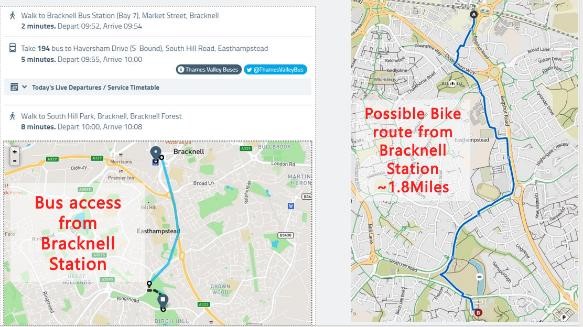
Event HQ is the South Hill Park Arts Centre, Ringmead, Bracknell, RG12 7NF. What 3 Words, W3W: ///cattle.lofts.lies is the entrance to the car-park. Bracknell station is 2 miles N of the Event HQ. Bus and cycle/walking routes from the station are shown in detail below. There is no supervised or reserved car-parking for the event. Important: please do NOT use on-street parking in the residential streets around South Hill Park. Please do use one of the car-parking options, available on first-come, first-served and ‘use at own risk’ as given in the detail below. |
|
Facilities: |
The following facilities are available :.
|
|
Registration: |
Registration (eTag collection) will be at or near the Terrace Room of South Hill Park Arts Centre. This is the SW corner and will be taped from the car-park. Registration opens at 10:00. Start times are 10:30 to 12:30 in 15-minute slots, courses close at 14:00. Individual start times will be published on Race Sign-up and displayed at Assembly. |
|
EOD |
There is no Entry On Day (EOD) for this event. Please enter via Race Sign Up, until midnight weds 26th Jan (subject to availability again limit of 250). The Concorde Chase Weekend - Information and sign up (racesignup.co.uk) |
|
eTag Issue and Return: |
The entry fee includes mandatory hire of an eTag. Only the hired eTag can be used for the competition. A charge of £50 will be made for lost cards. At Assembly, please check the Start List to find your eTag number. Collect your individual eTag from the display box and take a strap (self-service). Fix the eTag to your wrist following displayed directions. BKO Events team will be on hand to check you have the right tag, fitted correctly. Lastly please check correct functioning of the eTag against the Demo Control NOTE Regarding use of EMIT: It is the competitor’s responsibility to check that their eTAG has been registered, including any pin-punch if needed, at each control and the Finish. Reinstatement for missing electronic punches will only be made on visible evidence of the correct pin punch on the map. |
|
Start |
Start is located near a grassy knoll on the W side of the car park, about 200m from Assembly (taped). It is a punching start, we will be flexible subject to numbers, and allow people to go soon before or after their allocated time. Make your way to the Start in suitable time but not too soon, Please aim to be at Start 5 minutes before your start-time slot, but not sooner to minimise queue build-up in an area also used by members of the public |
|
Road Crossings |
Courses 1,2,3: Between the estates (Birch Hill, Great Hollands), there is a major uncrossable OOB road marked with red hatching on the map. Three pedestrian underpasses are available to transfer between the estates. All other roads may be crossed, please take care on busy roads mapped with darker shading. Courses 4 and 5: These stay in Birch Hill and use a single-sided A3 map. All roads may be crossed Please take care on all road crossings and take particular care on roads mapped with darker shading. Courses 6 and 7: These stay in Birch Hill and use a single-sided A3 map. These courses have been planned for juniors. Course 7 makes use of the path network and can be completed without crossing any roads. Course 6 uses areas of the estate with cul-de-sacs which may have slow-moving traffic. On both courses, there are 2 designated mandatory underpasses. These are not manned but controls have been sited to ensure that they are used. Control descriptions for 6 & 7 use text.
Parents and guardians; please ensure juniors in your care are aware of these points. |
|
Pin-punch |
In the unlikely event a control on the course is found by a competitor not to be working, it is the competitor’s responsibility to use the pin-punch to mark their map. Reinstatement for missing electronic punches will only be made on visible evidence of the correct pin punch on the map. |
|
Course |
Length |
Climb |
No. controls |
Descriptions |
|
1 |
7.6km |
70m |
|
Pictorial |
|
2 |
6.7km |
65m |
|
Pictorial |
| 3 |
5.7km |
55m |
|
Pictorial |
| 4 |
4.9km |
50m |
|
Pictorial |
|
5 |
3.9km |
40m |
|
Pictorial |
|
6 |
3.4km |
40m |
|
Text |
| 7 |
2.1km |
30m |
|
Text |
|
Course Close |
Courses closes at 14:00 |
|
Finish |
There is one finish for all courses, located in the grounds to S of the South Hill Park Arts Centre. From there, follow taped route to Download (~100 m) ALL competitors must report to DOWNLOAD, even if they retire. You MUST hand in your eTag, even if you are running in the Forest event tomorrow. You will be issued a fresh (not used on Saturday) eTag for Sun event. Your race result will be available via EMIT results service www.race-results.info within a few minutes. |
|
Map |
Maps are size A3, printed on waterproof paper. Scale 1:4000 with 2.5m contours. The map has been fully updated during October 2021 to January 2022. It is drawn to ISSOM2007 but roads with heavier traffic have been given a darker shading. On the map, a black ‘X’ represents both benches and play equipment. In control descriptions, an ‘X’ represents a bench. Control descriptions are printed on all maps, and loose CDs are also in Start lanes. |
|
Map turns - Course 1 - 3 only |
Courses 1, 2 and 3: These use a double-sided A3 map with Birch Hill on front and Great Hollands on back. Early parts of the course and the last part are shown on the front. Leaving Birch Hill there is no designated ‘map turn over’ shown on the map - the red line goes off the edge. However, the last control before that edge is shown on both maps. The CD indicates ‘Turn map over’ at this control.
On returning to Birch Hill, the last control marked is also shown on the Birch Hill map: turn the map back over at this point. – again the CD states ‘Turn map over’. |
|
Terrain |
Terrain: The area being used includes Birch Hill and Great Hollands estates. See: SEOUL Routegadget 2018 for previous event on this terrain. Courses 1, 2 and 3 use both estates. Courses 4, 5, 6 and 7 use Birch Hill only. |
|
General Safety: |
Please be mindful of other users of the area, especially residents going about normal activities. Do NOT enter any area marked in olive green (private property, out of bounds), nor any area or street marked out of bounds. Please take care on all road crossings and take particular care on roads mapped with darker shading. |
|
Race Day updates |
BKO Bracknell Urban 29/Jan 2022 Planner’s Notes – Race Day updates
Courses 1, 2 and 3: There is ongoing work to install fibre optic cables in Great Holland (part 2 of the map). This is affecting a few paths. Although mostly still open, you may see a ‘Footpath Closed’ sign. If there is active work in the area, please respect the sign and find an alternative route. If no work is occurring, please assess the situation and, if appropriate, proceed but with caution.
|
|
Accidents: |
Accident & Emergency: Frimley Park Hospital Portsmouth Road Camberly GU16 7UJ Minor Injuries: Bracknell Healthspace Tel: 01344 551100 Eastern Gate Brants Bridge Bracknell RG12 9TR |
|
Officials |
Planner: David Jukes Organiser: Eoin Sharkey 07957 801 673 Email: events@bko.org.uk Controller: Pete Jones |
|
Detail: Advice on transport to the event |
Car-parking options: South Hill Park Arts Centre Main Car-park, is free of charge, (no duration limit) and close to Assembly, Start and Finish. Please fill up from the W side, which is less used by public. Please do not use spaces in front of (N side) of the Arts, which are marked for coaches, deliveries etc. Alternative is Leppington Car-Park which is one mile drive from South Hill Park via Ring Mead (anti-clockwise) and Birch Hill Road. However, it is only about 250m level walk on footpath to Assembly/Start. The route to Assembly will be taped but not signed.
Overflow option is Birch Hill Recreation Ground car-park, also free and with no time-limits. It is about 750m walk to Assembly via Hillberry and Birch Hill path network. Walking anti-clockwise around Ringmead is slightly longer but avoids sight of the courses. Allow 15 – 20 minutes if using this car-park option. Route to Assembly will NOT be signed or taped. see map :
http://www.bko.org.uk/sites/default/files/images/CarParking.png Non-car options:Bracknell railway station has hourly service on South West Trains between Reading and SW London.
http://www.bko.org.uk/sites/default/files/images/PublicTransport.jpg |
|
Info: Layout of competition area |
|
|
Bio Security Advice |
Please come to the event with clean and dry shoes and clothing. After your run please follow the guidance that helps protect our precious environment: · Check · Clean · Dry Before leaving the event check your clothing and equipment and remove any mud, soil or leaf litter. Once home thoroughly clean your footwear and clothing and then leave it to dry for as long as possible. Many invasive non-native species are able to survive in damp corners for very long periods of time, but are less able to survive if the equipment is thoroughly dried. |
|
Photography |
The club has designated photographer(s) and details are available from Enquiries.
Photographs from the event may be used by the club and made available on the internet in accordance with British Orienteering guidelines. Please speak to a club official at registration if you have any concerns |


|
IMPORTANT OFFICIAL NOTICES:
|
|
Sunday 16th May Bloom Wood south of High Wycombe Level C and Yvette Baker Trophy Qualifying Event Final Details (as of 14th May) |
Berkshire Orienteers welcome you to the event! Finally having an open event is exciting but we are aware that precautions still need to be taken for everyone's safety. Please keep to the Participant Code of Conduct especially the social distancing necessary. Also please allow for the restricted nature of some aspects of the layout and organisation that are needed at these times.
|
Travel: |
Location Monkton Lane, off Marlow road just south of Handy Cross roundabout (Junction 4 on M40) Directions Note that the M4 is closed this weekend between Junction 6 (Slough) and Junction 8/9 (Maidenhead) Parking For BKO members only - please park to south of woods via Pump Lane accessed from Three Horseshoes at SU 857 891 If you have your own emit you can then access the start directly by going north up the track and following signs. If you need to hire then continue on up track to car parking field for emit collection. Everyone will need to go to car parking field for Download Everyone else · Parking in Monkton Barn car park, Monkton Lane, Marlow, SL7 3RF. SU 858899, what three words: mining.owner.emerge. Please only enter Monkton Lane from the north and exit to the North. Signposted from the junction of Wycombe Rd and Winchbottom Lane. Monkton Lane is single track, but two vehicles should be able to pass with care. Be prepared to meet oncoming traffic. · Car park entrance is narrow, two way AND shared with pedestrians. TAKE CARE! Parking is limited so overflow cars may need to return to park at entry to Monkton Lane near the junction with Winchbottom Lane. If you live locally please consider arriving on foot or by bicycle.
|
|
Facilities: |
The following facilities are available in the Assembly field:. First Aid - located close to download Toilets - Sanitisers will be on the outside, so please make use of them before and after touching anything. There will be no post race water or squash. Please bring your own drinks, and any refreshments needed.
|
|
Registration: |
All entries are Pre-entries via Fabian 4.
Start times are between 10:30 and 12:30. Start times are in blocks and will be marshalled to keep to social distancing but hopefully allowing a regular flow of competitors |
|
EOD |
No Entry on the Day |
|
String Course |
Sorry, no string course |
|
Emit Card Issue and Return: |
Competitors hiring Emit cards should collect them from Enquiries before going to the start. They will be in named envelopes ready to pick up. Hired Emit cards will be collected back at download. A charge of £45 will be made for lost cards. NOTE Regarding use of EMIT: It is the competitor’s responsibility to check that their EMIT card has been registered. Following BOF guidelines back up cards will not be issued, please accept any problems due to this. |
|
Start |
· There are Two Starts, approx. 50m apart, both 500m from car park exit. Follow red and white tape from the entrance of the parking field, down track and into the woods to the starts Start 1 - Yellow, Orange, Light Green and Junior Green. Start 2 – Senior Green, Blue and Brown At the start please observe social distancing. No more than 2 competitors can start at the same time so that there may be some slight adjustment to allow for this. Each start will have separate queues for each course. Please join the appropriate queue as soon as you arrive at the Start. The Start is a punching start Loose control description sheets will NOT be available in the start lanes. They can be downloaded beforehand from the link at the top of this page.
|
|
Road Crossings |
One minor road crosses the area. Yellow and Orange courses do not cross the road. Light Green and Junior Green have a manned crossing where a marshall will advise on crossing. Green, Blue and Brown Courses do cross the road but competitors may cross anywhere and and at their own discretion. Please be aware traffic is infrequent but can be fast.
|
|
Course |
Length |
Climb |
No. controls |
Descriptions |
|
|
|
|
|
|
|
Yellow |
1.9km |
60m |
6 |
Text |
|
Orange |
3.0km |
105m |
10 |
Text |
|
Light Green |
4.3km |
120m |
13 |
Pictorial |
|
Junior Green |
4.6km |
115m |
14 |
Pictorial |
|
Senior Green |
4.8km |
155m |
13 |
Pictorial |
|
Blue |
6.7km |
205m |
14 |
Pictorial |
|
Brown |
8.3km |
330m |
22 |
Pictorial |
|
Course Close |
Courses closes at 2.30 |
|
Finish |
There is one finish for all courses, about 600 metres from car park (and not far from the start area) . – Follow red/white tapes back to track and the car park field. Keep to social distancing while waiting to Download at the Download tent. ALL competitors must report to the DOWNLOAD tent even if they retire.
|
|
Yvette Baker Trophy qualifying results
|
Yvette Baker Trophy qualifying results will be published on the club web-site after the event. |
|
Map |
The map is at 1:10,000 scale, with 5m contours, on A4 waterproof paper and conforms to ISOM2017-2. Double-sided for Brown |
|
Terrain |
The typical Chiltern terrain consists of several large spurs separated by valleys. The wood has a good path network and quite reasonable runnability. Note that, as a result of COVID and additional walkers in the area, a number of paths have become wider, and some unmapped additional paths have appeared to avoid muddy areas. The vegetation has seen some recent growth, but should not impede progress. The courses have been designed to keep you out of the rougher bits of the forest. |
|
Bio Security |
Please come to the event with clean and dry shoes and clothing. After your run please follow the guidance that helps protect our precious environment: · Check · Clean · Dry Before leaving the event check your clothing and equipment and remove any mud, soil or leaf litter. Once home thoroughly clean your footwear and clothing and then leave it to dry for as long as possible. Many invasive non-native species are able to survive in damp corners for very long periods of time, but are less able to survive if the equipment is thoroughly dried. |
|
Photography |
The club has designated photographer(s) and details are available from registration. Photographs from the event may be used by the club and made available on the internet in accordance with British Orienteering guidelines. Please speak to a club official at registration if you have any concerns |
|
General Safety: |
-In entering this event you have signed up to a Participant Code of Conduct Everyone taking part must follow the Participant Code of Conduct at all times. The Code of Conduct can be found on the British Orienteering website. The key considerations include: • Acting as an ambassador for the sport of orienteering at all times and considering how their actions may appear in the eyes of landowners or members of the public. • Observing social distancing at all times, including keeping their distance from other participants, volunteers and members of the public. • Using hand sanitizer on arrival and departure. Anyone who has symptoms of COVID-19, who is living in a household with someone who has a possible or confirmed COVID-19 infection, or who has been asked to isolate by NHS Test and Trace should remain at home. People who are classified as clinically extremely vulnerable can now consider taking safe exercise outdoors and meeting up with one person outside their household; however, it is unlikely that they would be able to safely take part in an organised orienteering event or activity. - Public Access. Bloom Woods are used by the public for walking, running, dog walking, cycling and horse riding on public paths. Please be courteous towards other users, especially those with dogs and horse riders – our future use of these areas depends on this. And please try to keep your distance from others. The woods have numerous “Private Woodland – No public Access” or similar signs. Competitors can ignore these. - Clothing and Safety Equipment. Competitors' torso and legs must be covered. For safety reasons we strongly recommend you carry a whistle. The distress signal is six short blasts, wait one minute, and then repeat. - Emergency Number. All maps will be overprinted with a phone number which can be used on the day to contact the Organiser in the event of an emergency. - Please report to download even if retiring as this will ensure we can check you have returned safely. Competitors travelling alone are encouraged to leave a set of keys at registration.
- Competitors take part at their own risk and are responsible for their own safety. |
|
Accidents: |
- First Aid by Face 2 Face Medical Ltd in Assembly field
·There is a Minor Injuries Unit at Wycombe Hospital High Wycombe HP11 2HB. The nearest A&E are at Wexham Park Hospital, Wexham, Slough, Berkshire, SL2 4HL Tel 01753 633000 or Stoke Mandeville Hospital, Mandeville Rd, Aylesbury HP21 8AL |
|
Officials |
Planner: Andrew Southwood BKO Organiser: Jane Courtier BKO Email: events@bko.org.uk Controller:Jim Prowting TVOC |
|
|
|
Saturday 10th April 2021 Bucklebury Common (Chapel Row) Saturday Event Final Details |
Berkshire Orienteers welcome you to the event!
|
Travel: |
Parking and assembly is on Chapel Row Village Green, opposite the Bladebone Inn. Please comply with Covid-19 guidelines, do not share transport, travel only in household bubbles. This is a good sized parking field and cars will be parked at a reasonable distance from each other so you can maintain social distancing. Entrance is via Grid Ref: SU57136965 nearest Postcode: RG7 6PD (what3words: mankind.breed.seducing). There is no charge for parking.
|
|
Facilities: |
There will be toilets near start/finish. There will be no water - please bring your own. PPE - please bring your own PPE if you require it. Hand sanitiser will be available.
|
|
Registration: |
This event is pre-entry only - there will be NO ENTRY ON THE DAY
Start times are between 10:30 and 12:00.
|
|
Covid-19 |
You should not enter or attend:
A full refund will be given if you are unable to attend for any of the above reasons after an entry has been made. |
|
|
|
|
Emit Card Issue and Return: |
Competitors hiring Emit cards should collect them from Enquiries before going to the start. Hired Emit cards will be collected at download. A charge of £45 will be made for lost cards. NOTE Regarding use of EMIT: It is the competitor’s responsibility to check that their EMIT card has been registered, including on the back-up card, at each control and the Finish. Reinstatement for missing electronic punches will only be made on visible evidence of the correct pin punch on the back-up card. Hire cards will include back-up card on collection. Spare back-up cards will be available at Registration. |
|
Start/Finish |
Five minutes' walk from the assembly field, reached by compulsory manned road crossings. |
|
Road Crossings |
There is a manned road crossing (two-way) on all courses. The short distance between the assembly field and the Start/Finish also includes manned road crossings. The Blue course has several unmanned crossings; for this reason, it is not possible for Juniors to enter the Blue course. |
|
Course |
Length |
Climb |
No. of controls |
Descriptions |
|
Orange |
3.7km |
45m |
17 controls | Text |
|
Light Green |
4.2km | 60m | 18 controls | Pictorial |
|
Green |
4.9km |
95m |
19 controls |
Pictorial |
|
Blue |
7.6km |
125m |
22 controls | Pictorial |
|
|
|
|||
|
|
|
Courses close |
Courses close at 13.30 |
|
Finish |
There is one finish for all courses. ALL competitors must report to the DOWNLOAD tent, even if they retire.
|
|
|
|
|
Map |
Scale 1:10,000, 5m contours, updated 2019. Courses and control descriptions will be over printed on waterproof paper Note that seasonal bracken is not mapped. |
|
Terrain |
Areas of heathland and mainly deciduous woodland interspersed with dwellings - all with a complex path and track network. Some detailed contours and features on the north side of the map. It is 10 years since most of the area has been used for an event. There are some extraction lanes, seasonal and animal tracks which are not on the map. Bracken has been avoided as much as possible on the courses. There are numerous small paths dotted about the area.
|
|
Bio Security |
Please come to the event with clean and dry shoes and clothing. After your run please follow the guidance that helps protect our precious environment: · Check · Clean · Dry Before leaving the event check your clothing and equipment and remove any mud, soil or leaf litter. Once home thoroughly clean your footwear and clothing and then leave it to dry for as long as possible. Many invasive non-native species are able to survive in damp corners for very long periods of time, but are less able to survive if the equipment is thoroughly dried. |
|
Photography |
The club has designated photographer(s) and details are available from registration. Photographs from the event may be used by the club and made available on the internet in accordance with British Orienteering guidelines. Please speak to a club official at registration if you have any concerns |
|
General Safety: |
- Please take care when crossing and walking along Forest roads. - There is public access to Bucklebury Common; please respect the rights of others, particularly the horse riders. - Please report to download even if retiring as this will ensure we can check you have returned safely. Competitors travelling alone are encouraged to leave a set of keys at registration. - Competitors are advised to carry whistles. - Competitors take part at their own risk and are responsible for their own safety. |
|
Accidents: |
There will be a BKO First Aider present. Nearest Hospitals: Accident & Emergency Minor Injuries Unit (11½ miles; 26 mins. by car) (6 miles; 12 mins. by car) |
|
Officials |
Planner: Glyn Thomes (BKO) aided by Mark Saunders (BKO) Organiser: Steve Waite (BKO) Email: events@bko.org.uk Controller: Mark Foxwell (BKO) |
|
IMPORTANT OFFICIAL NOTICES:
|